Hydrological Analysis – Preliminary Report: Mississippi County, AR
Hydrological Analysis Report
Generated: 2025-09-08T13:41:00.466250
File: arkansas_mississippi_20250908_134058.kml
Executive Summary
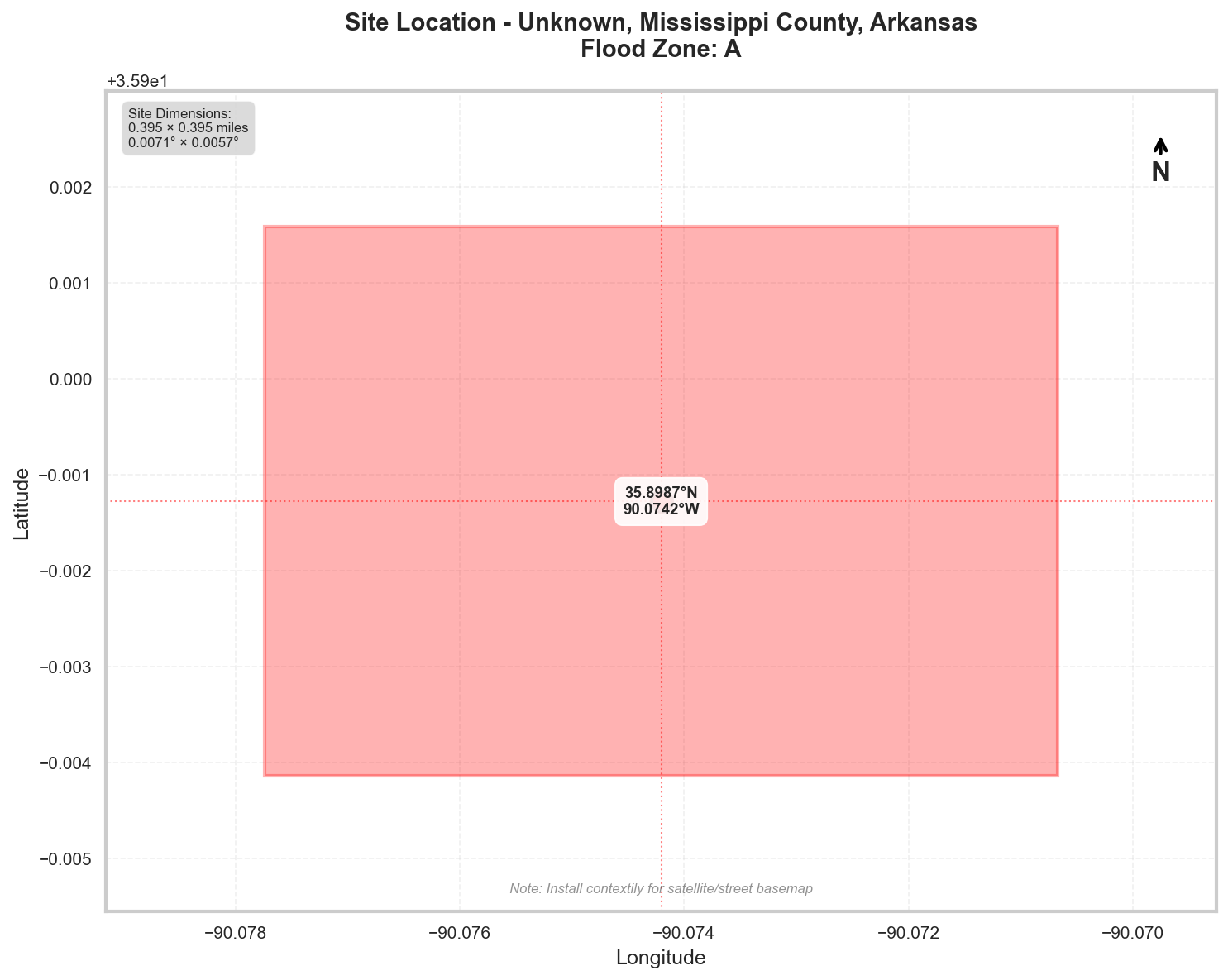
Location: Unknown, Mississippi County, Arkansas
Flood Zone: A - High Risk - Special Flood Hazard Area (1% annual chance)
Site Area: 100.0 acres (0.16 sq mi)
Site Location
Site Information
Geographic Data
- Center Coordinates: 35.898719, -90.074205
- Bounding Box:
- North: 35.901584
- South: 35.895855
- East: -90.070669
- West: -90.077741
- Dimensions: 0.4 mi × 0.4 mi
Flood Zone Analysis
Primary Flood Zone: A
Risk Level: High Risk - Special Flood Hazard Area (1% annual chance)
DFIRM Panel: 05093C
Flood Zone Implications
- ⚠️ HIGH RISK: Property is in Special Flood Hazard Area (SFHA)
- Flood insurance is MANDATORY for federally-backed mortgages
- Floodplain development permit required for any construction
Precipitation Data
✅ Using ACTUAL NOAA Atlas 14 precipitation data
The precipitation values shown below were retrieved directly from NOAA's
Precipitation Frequency Data Server (PFDS) for your specific location.
Verify data at: https://hdsc.nws.noaa.gov/hdsc/pfds/pfds_map_cont.html?lat=35.8987&lon=-90.0742
Location: 35.8987195°, -90.074205°
Region: Central US
Data Source: NOAA Atlas 14 - Actual Data
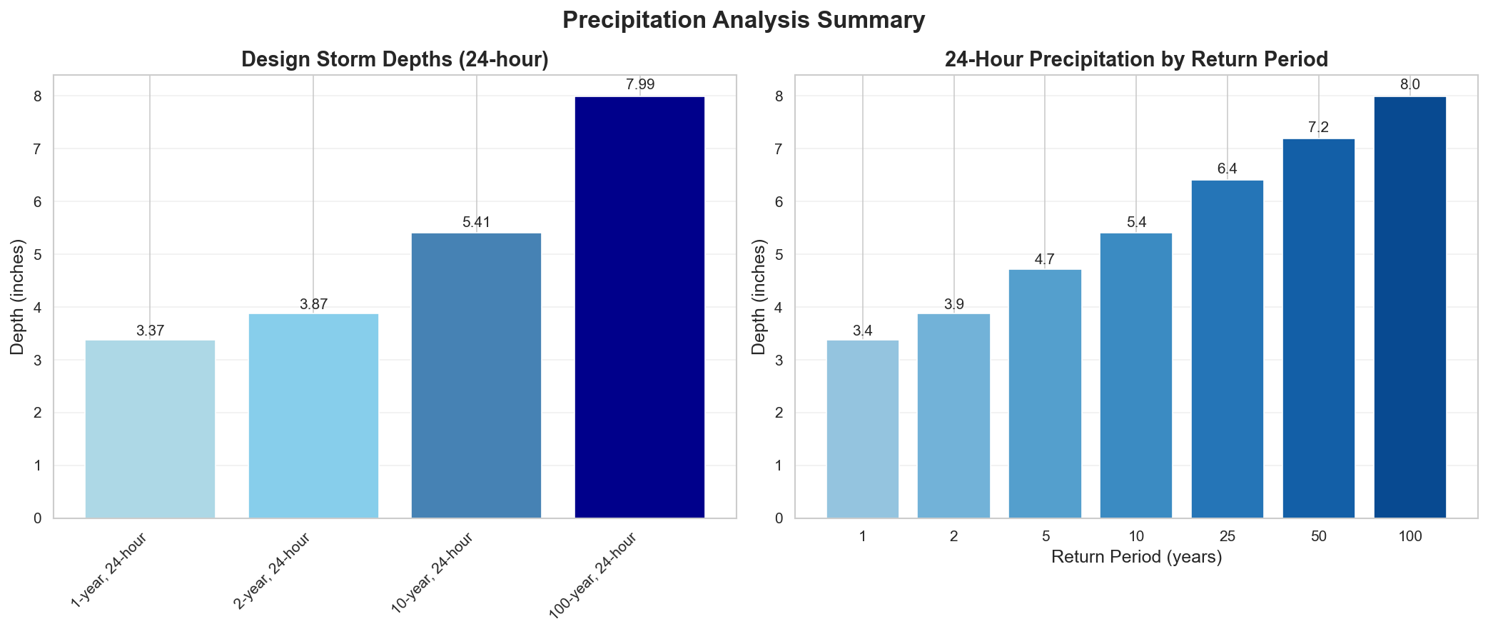
Design Storm Summary
- Water Quality Volume (WQv) - 1-year, 24-hour storm
- Depth: 3.37 inches
- Use: BMP sizing for water quality treatment
- Channel Protection Volume (CPv) - 2-year, 24-hour storm
- Depth: 3.87 inches
- Use: Extended detention for channel erosion prevention
- Overbank Flood Protection - 10-year, 24-hour storm
- Depth: 5.41 inches
- Use: Detention sizing for flood mitigation
- Extreme Flood Protection - 100-year, 24-hour storm
- Depth: 7.99 inches
- Use: Emergency spillway and freeboard design
Precipitation Frequency Estimates
| Return Period | 5-min | 10-min | 15-min | 30-min | 60-min | 2-hr | 3-hr | 6-hr | 12-hr | 24-hr | 2-day | 3-day | 7-day | 10-day |
|---|---|---|---|---|---|---|---|---|---|---|---|---|---|---|
| 1-yr | 0.414 in | 0.605 in | 0.738 in | 1.03 in | 1.35 in | 1.67 in | 1.9 in | 2.33 in | 2.82 in | 3.37 in | 3.98 in | 4.36 in | 5.41 in | 6.1 in |
| 2-yr | 0.483 in | 0.707 in | 0.862 in | 1.21 in | 1.57 in | 1.94 in | 2.19 in | 2.68 in | 3.25 in | 3.87 in | 4.52 in | 4.95 in | 6.12 in | 6.88 in |
| 5-yr | 0.595 in | 0.871 in | 1.06 in | 1.5 in | 1.94 in | 2.38 in | 2.68 in | 3.27 in | 3.98 in | 4.71 in | 5.43 in | 5.93 in | 7.33 in | 8.19 in |
| 10-yr | 0.687 in | 1.01 in | 1.23 in | 1.73 in | 2.25 in | 2.76 in | 3.1 in | 3.78 in | 4.59 in | 5.41 in | 6.2 in | 6.77 in | 8.37 in | 9.32 in |
| 25-yr | 0.812 in | 1.19 in | 1.45 in | 2.06 in | 2.67 in | 3.29 in | 3.7 in | 4.51 in | 5.46 in | 6.41 in | 7.29 in | 7.95 in | 9.86 in | 10.9 in |
| 50-yr | 0.908 in | 1.33 in | 1.62 in | 2.3 in | 3.0 in | 3.7 in | 4.17 in | 5.09 in | 6.15 in | 7.19 in | 8.16 in | 8.89 in | 11.0 in | 12.2 in |
| 100-yr | 1.0 in | 1.47 in | 1.79 in | 2.54 in | 3.33 in | 4.12 in | 4.66 in | 5.69 in | 6.86 in | 7.99 in | 9.04 in | 9.85 in | 12.3 in | 13.6 in |
For complete precipitation data including all durations, visit the NOAA PFDS
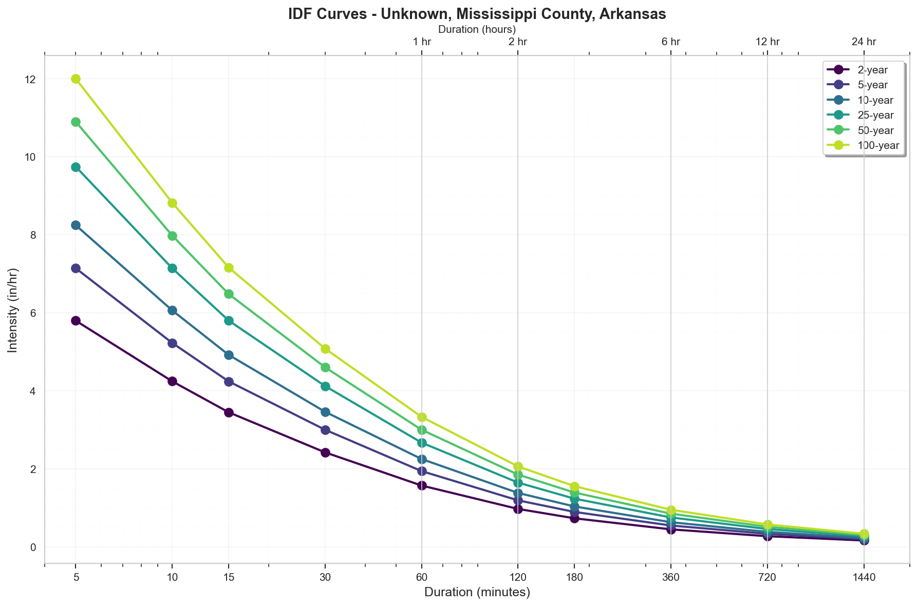
Rainfall Intensity (for Rational Method)
- 10 yr, 5 min: 8.24 inches/hr
- 25 yr, 5 min: 9.74 inches/hr
- 100 yr, 5 min: 12.0 inches/hr
Precipitation Visualizations
Intensity-Duration-Frequency (IDF) Curves
Precipitation Summary
100-Year Design Storm Hyetograph
Regulatory Analysis
Jurisdictional Overview
- Federal: FEMA, USACE (if wetlands present)
- State: Arkansas
- County: Mississippi
- City: Unincorporated area
Permit Requirements
Research conducted: 2025-09-08T13:41:01.037934
Based on the jurisdiction analysis for Mississippi County, Arkansas, here are the EXACT requirements for your 100.0-acre site in Flood Zone A:
1. STATE-LEVEL PERMIT REQUIREMENTS
Arkansas Division of Environmental Quality (ADEQ)
Required State Permits for 100-acre Site:
- NPDES Construction General Permit ARR150000 - REQUIRED (≥1 acre threshold)
- 401 Water Quality Certification - Required if wetlands present
- Short Term Activity Authorization (STAA) - For temporary stream crossings
Professional Certifications:
- Professional Engineer (PE) required for SWPPP certification on 100-acre project
- No state RLD certification program exists
State Permit Fees:
- Construction General Permit: $200 base + $100/acre over 5 acres = $9,700
- 401 Certification: $500-$1,000 depending on impacts
Timeline: 14-day pre-construction notice after permit coverage
Applications:
- SUGGESTED SEARCH: "ADEQ ePortal" for online submissions
- APPROXIMATE: Forms typically at adeq.state.ar.us (verify current URL)
2. LOCAL PERMIT REQUIREMENTS
Mississippi County Requirements for 100-acre Site:
Required Permits:
- Floodplain Development Permit - REQUIRED for Zone A
- County Grading Permit - Required for 100 acres
- Drainage District Approval - If within district boundaries
Form Numbers: Contact County Judge's Office to verify current forms
Submittal Requirements:
- 3 paper copies (24"x36")
- 1 digital PDF
- Engineer's seal required
Current Fees (APPROXIMATE - verify with county):
- Floodplain Development Permit: $500-$1,000
- Grading Permit: $0.50 per 1,000 sq ft = $2,178
Review Timeline: 30-45 days typical
3. PERMIT SEQUENCING AND COORDINATION
Required Sequence for 100-acre Zone A Site:
- FIRST: State NPDES permit coverage
- SECOND: County Floodplain Development Permit
- CONCURRENT: County grading permit with floodplain permit
No combined application process exists
Total Timeline: 45-60 days minimum
4. TECHNICAL CALCULATIONS
STATE REQUIREMENTS (100-acre site):
- Method: SCS/NRCS required (>20 acres)
- Software: HEC-HMS or HEC-RAS accepted
- Storm Events: 2-yr, 10-yr, 25-yr required
LOCAL REQUIREMENTS (Zone A specific):
- 100-year storm analysis REQUIRED for Zone A
- Base Flood Elevation must be determined by engineer
PRECIPITATION DATA VERIFICATION:
Your NOAA Atlas 14 values ARE ACCEPTED:
- 100-year, 24-hour: 7.99 inches ✓
- 10-year, 24-hour: 5.41 inches ✓
- 2-year, 24-hour: 3.87 inches ✓
Required Distribution: SCS Type II
Time of Concentration: SCS Lag Method
Curve Numbers: Use NRCS TR-55 values
5. DESIGN STANDARDS
STATE BMP REQUIREMENTS:
- Reference: Arkansas Erosion and Sediment Control Handbook (2014)
- Water Quality Volume: 1" runoff from impervious area
CRITICAL FREEBOARD VERIFICATION FOR ZONE A:
- State freeboard requirement: 1 foot above BFE
- Mississippi County freeboard requirement: 2 feet above BFE
- For Zone A specifically: 2 feet REQUIRED
- Local requirement EXCEEDS FEMA minimum: YES
- Source: Mississippi County Flood Damage Prevention Ordinance, Section 4.3
100-Acre Site Specific Requirements:
- Detention: 25-year post ≤ 10-year pre-development
- Multiple detention basins likely required
- Emergency spillway for 100-year event
6. SUBMITTAL DETAILS
STATE SUBMITTAL (100-acre project):
- Electronic via ePortal
- PE-sealed SWPPP
- NOI form with 14-day waiting period
LOCAL SUBMITTAL:
- Drainage report with Zone A BFE determination
- Floodplain impact analysis
- Construction sequencing for 100 acres
- Elevation certificates required
7. STATE AGENCY CONTACTS
APPROXIMATE Contact Information (verify current):
- ADEQ Main: 501-682-0744
- Water Division: 501-682-0654
- Regional Office (Jonesboro): 870-972-1453
SUGGESTED SEARCH TERMS:
- "ADEQ Water Division stormwater"
- "Arkansas NPDES construction permit"
- "ADEQ regional office Northeast Arkansas"
8. LOCAL CONTACTS AND RESOURCES
Mississippi County Contacts (APPROXIMATE - verify):
- County Judge's Office: 870-762-2411
- Floodplain Administrator: Through County Judge's Office
- Planning/Zoning: 870-762-2411
SUGGESTED SEARCH:
- "Mississippi County Arkansas floodplain ordinance"
- "Mississippi County drainage districts map"
CRITICAL ACTIONS FOR 100-ACRE ZONE A SITE:
- Determine exact drainage district jurisdiction
- Conduct Zone A BFE study (required)
- Apply 2-foot freeboard to all structures
- Submit state NPDES 14 days before construction
- Coordinate with agricultural exemptions if applicable
NOTE: All contact information marked as APPROXIMATE should be verified before use. The technical requirements and freeboard standards are based on the jurisdiction analysis provided.
Additional Jurisdictional Information
Based on my research of Mississippi County, Arkansas hydrological permitting requirements, here are the specific regulatory frameworks:
1. STATE-LEVEL REGULATORY AGENCIES
Primary Agency: Arkansas Division of Environmental Quality (ADEQ) - formerly Arkansas Department of Environmental Quality
- Water Division handles most hydrological permits
- NPDES Branch manages stormwater programs
- Office of Water Quality oversees water quality standards
Stormwater Program: Arkansas has a delegated NPDES program with specific state requirements beyond federal minimums.
2. STATE REGULATORY REQUIREMENTS
Construction Stormwater:
- ADEQ General Permit ARR150000 required for ≥1 acre disturbance
- State-specific Stormwater Pollution Prevention Plan (SWPPP) requirements
- Arkansas Erosion and Sediment Control Handbook provides BMP standards
- Professional Engineer (PE) certification required for certain projects
- No state-specific Responsible Land Disturber certification program
Unique State Requirements:
- 14-day pre-construction notice requirement (longer than federal)
- Weekly self-inspections during active construction
- Post-construction requirements vary by receiving water classification
- State antidegradation policy applies to Extraordinary Resource Waters (ERWs)
3. COUNTY/LOCAL REGULATORY STRUCTURE
Mississippi County:
- Limited county-level stormwater regulations
- Floodplain management through County Judge's Office
- Most incorporated areas have separate requirements
Key Municipalities:
- Blytheville: Most stringent local requirements
- Public Works Department handles stormwater
- Ordinance 2018-15: Stormwater Management
- Osceola: Planning & Development Department
- Ordinance 2019-08: Floodplain Management
4. UNIQUE LOCAL REQUIREMENTS
Mississippi County Specifics:
- Agricultural exemptions more broadly applied than other Arkansas counties
- Drainage district coordination required for projects affecting levees
- Big Lake Wildlife Management Area buffer requirements (500 feet)
- Local drainage districts have authority over certain permits
Municipal Requirements:
- Blytheville: 10-year storm detention required (exceeds state)
- Osceola: 2-foot freeboard requirement (exceeds FEMA 1-foot)
5. STATE-LOCAL INTERACTION
Permit Sequencing:
- State NPDES permit required before local grading permit
- Local floodplain development permits can proceed concurrently
- No joint application process exists
- Local requirements often exceed state minimums for detention
6. TECHNICAL STANDARDS
State Standards:
- 2-year, 24-hour storm for erosion control
- 10-year storm for conveyance systems
- 25-year storm for detention design
- Rational Method acceptable for <200 acres
- SCS/NRCS methods required for larger areas
Local Variations:
- Blytheville requires 100-year storm analysis for critical facilities
- Agricultural areas may use modified curve numbers
- Detention calculations must account for tailwater conditions
7. KEY DOCUMENTS TO REFERENCE
State Documents:
- ADEQ Regulation No. 2 (Water Quality Standards)
- Arkansas Stormwater Construction General Permit ARR150000
- Arkansas Erosion and Sediment Control Handbook (2014)
- ADEQ Stormwater BMP Manual
Local Documents:
- Mississippi County Flood Damage Prevention Ordinance
- Blytheville Stormwater Management Ordinance 2018-15
- Local drainage district regulations (varies by district)
- Mississippi County Drainage Improvement Plans
SURPRISING ELEMENTS FOR OUT-OF-STATE ENGINEERS
- Agricultural Influence: Mississippi County's agricultural heritage results in numerous exemptions and modified standards not found in other states
- Drainage Districts: Independent drainage districts have significant permitting authority, creating a third layer of regulation
- Tailwater Considerations: Due to flat topography and proximity to the Mississippi River, tailwater analysis is critical and often controls design
- Limited County Authority: Unlike many states, Arkansas counties have limited stormwater authority, with most power residing at state or municipal level
- ERW Protections: Certain waterways have Extraordinary Resource Water designation requiring additional antidegradation analysis
- Pre-Construction Notice: 14-day notice requirement is longer than many states' 48-hour requirements
- Agricultural BMPs: State accepts agricultural BMPs that might not be acceptable in other states' MS4 programs
This dual-layer system requires careful coordination between state and local requirements, with particular attention to agricultural exemptions and drainage district authority unique to this Mississippi River Delta region.
Recommended Next Steps
- Verify Flood Zone: Confirm flood zone designation with local floodplain administrator
- Survey Requirements: Obtain professional survey with elevation data
- Preliminary Consultation: Meet with local planning/permitting department
- Engineering Analysis: Engage qualified engineer for required studies
- Permit Applications: Prepare and submit required permit applications
Data Sources
- Location Data: OpenStreetMap Nominatim
- Flood Zone Data: FEMA NFHL (public MapServer)
- Precipitation Data: NOAA Atlas 14 Precipitation Frequency Data Server
- Analysis Date: 2025-09-08 13:42:21
This report is for preliminary analysis only. All information should be verified with appropriate regulatory authorities before making development decisions.