Hydrological Analysis – Preliminary Report: Kings County, CA
Hydrological Analysis Report
Generated: 2025-09-08T13:27:21.766172
File: california_kings_20250908_132720.kml
Executive Summary
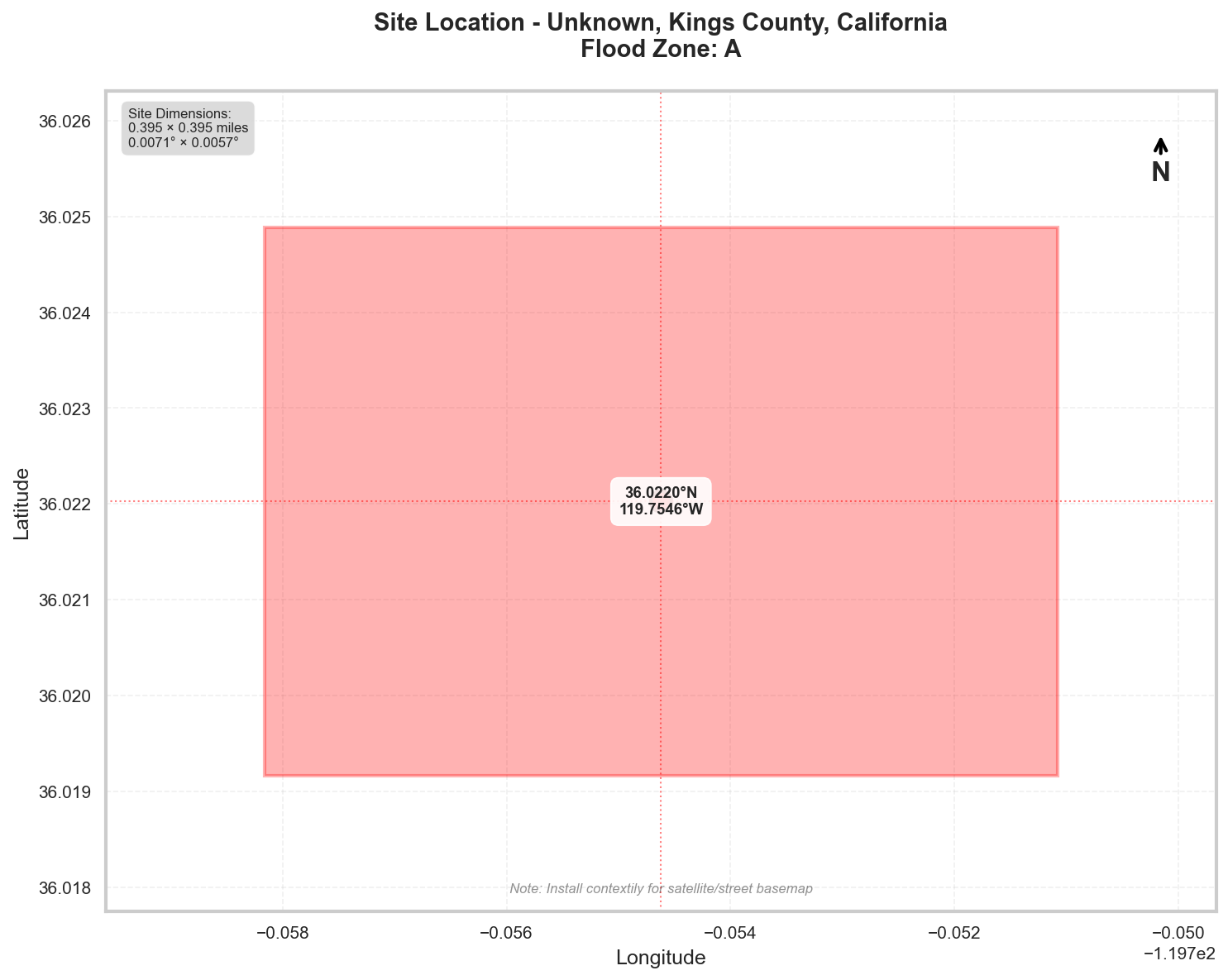
Location: Unknown, Kings County, California
Flood Zone: A - High Risk - Special Flood Hazard Area (1% annual chance)
Site Area: 100.0 acres (0.16 sq mi)
Site Location
Site Information
Geographic Data
- Center Coordinates: 36.022025, -119.754621
- Bounding Box:
- North: 36.024889
- South: 36.019160
- East: -119.751080
- West: -119.758163
- Dimensions: 0.4 mi × 0.4 mi
Flood Zone Analysis
Primary Flood Zone: A
Risk Level: High Risk - Special Flood Hazard Area (1% annual chance)
DFIRM Panel: 06031C
Flood Zone Implications
- ⚠️ HIGH RISK: Property is in Special Flood Hazard Area (SFHA)
- Flood insurance is MANDATORY for federally-backed mortgages
- Floodplain development permit required for any construction
Precipitation Data
✅ Using ACTUAL NOAA Atlas 14 precipitation data
The precipitation values shown below were retrieved directly from NOAA's
Precipitation Frequency Data Server (PFDS) for your specific location.
Verify data at: https://hdsc.nws.noaa.gov/hdsc/pfds/pfds_map_cont.html?lat=36.0220&lon=-119.7546
Location: 36.0220245°, -119.7546215°
Region: Western US
Data Source: NOAA Atlas 14 - Actual Data
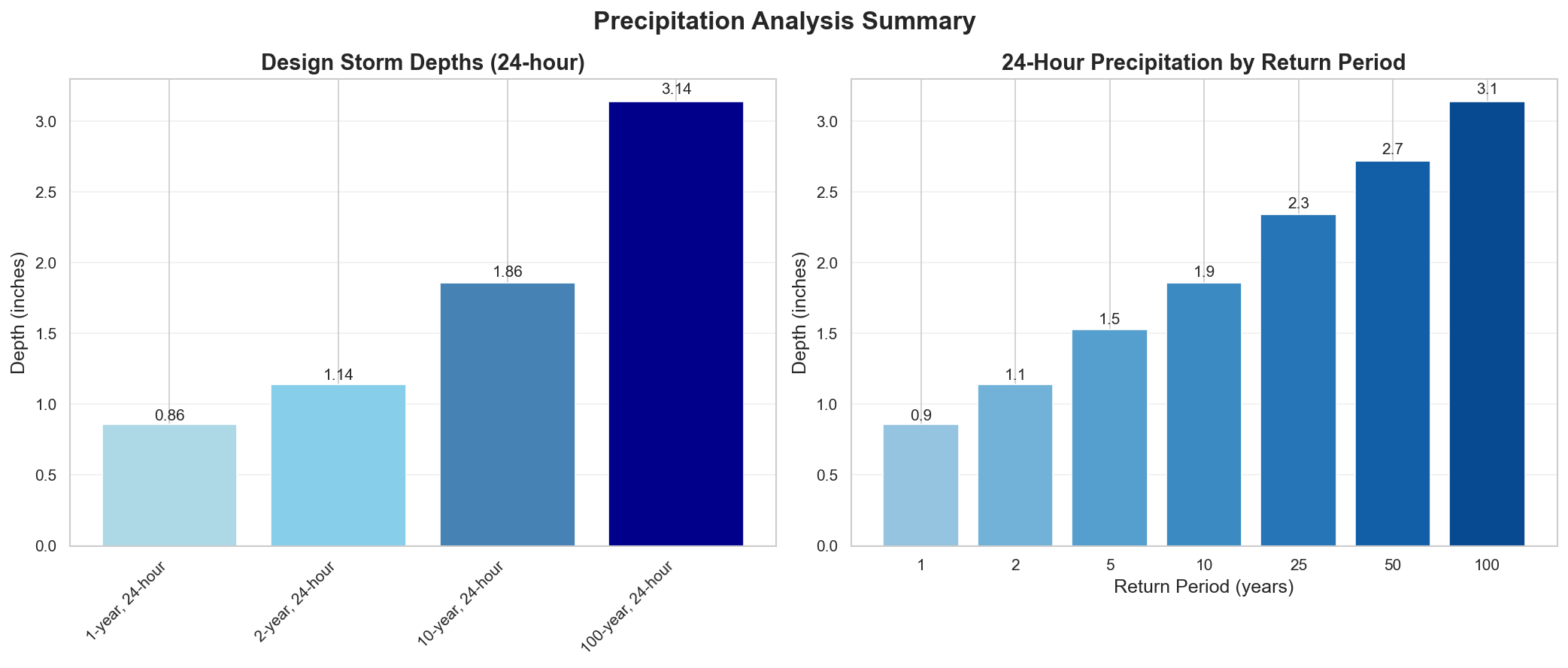
Design Storm Summary
- Water Quality Volume (WQv) - 1-year, 24-hour storm
- Depth: 0.859 inches
- Use: BMP sizing for water quality treatment
- Channel Protection Volume (CPv) - 2-year, 24-hour storm
- Depth: 1.14 inches
- Use: Extended detention for channel erosion prevention
- Overbank Flood Protection - 10-year, 24-hour storm
- Depth: 1.86 inches
- Use: Detention sizing for flood mitigation
- Extreme Flood Protection - 100-year, 24-hour storm
- Depth: 3.14 inches
- Use: Emergency spillway and freeboard design
Precipitation Frequency Estimates
| Return Period | 5-min | 10-min | 15-min | 30-min | 60-min | 2-hr | 3-hr | 6-hr | 12-hr | 24-hr | 2-day | 3-day | 7-day | 10-day |
|---|---|---|---|---|---|---|---|---|---|---|---|---|---|---|
| 1-yr | 0.066 in | 0.094 in | 0.114 in | 0.156 in | 0.219 in | 0.323 in | 0.398 in | 0.536 in | 0.683 in | 0.859 in | 1.04 in | 1.15 in | 1.46 in | 1.58 in |
| 2-yr | 0.086 in | 0.123 in | 0.149 in | 0.204 in | 0.286 in | 0.414 in | 0.509 in | 0.687 in | 0.892 in | 1.14 in | 1.38 in | 1.51 in | 1.9 in | 2.05 in |
| 5-yr | 0.115 in | 0.164 in | 0.199 in | 0.273 in | 0.382 in | 0.545 in | 0.668 in | 0.902 in | 1.18 in | 1.53 in | 1.84 in | 2.02 in | 2.53 in | 2.71 in |
| 10-yr | 0.14 in | 0.201 in | 0.243 in | 0.333 in | 0.467 in | 0.66 in | 0.807 in | 1.09 in | 1.43 in | 1.86 in | 2.24 in | 2.46 in | 3.08 in | 3.3 in |
| 25-yr | 0.178 in | 0.256 in | 0.309 in | 0.424 in | 0.594 in | 0.831 in | 1.01 in | 1.36 in | 1.8 in | 2.34 in | 2.82 in | 3.1 in | 3.88 in | 4.15 in |
| 50-yr | 0.211 in | 0.302 in | 0.365 in | 0.501 in | 0.702 in | 0.976 in | 1.19 in | 1.6 in | 2.1 in | 2.72 in | 3.3 in | 3.63 in | 4.54 in | 4.86 in |
| 100-yr | 0.247 in | 0.354 in | 0.428 in | 0.586 in | 0.821 in | 1.14 in | 1.38 in | 1.85 in | 2.42 in | 3.14 in | 3.82 in | 4.21 in | 5.26 in | 5.62 in |
For complete precipitation data including all durations, visit the NOAA PFDS
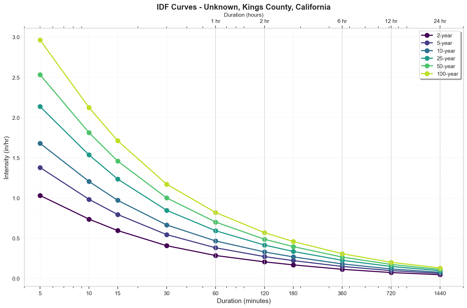
Rainfall Intensity (for Rational Method)
- 10 yr, 5 min: 1.68 inches/hr
- 25 yr, 5 min: 2.14 inches/hr
- 100 yr, 5 min: 2.96 inches/hr
Precipitation Visualizations
Intensity-Duration-Frequency (IDF) Curves
Precipitation Summary
100-Year Design Storm Hyetograph
Regulatory Analysis
Jurisdictional Overview
- Federal: FEMA, USACE (if wetlands present)
- State: California
- County: Kings
- City: Unincorporated area
Permit Requirements
Research conducted: 2025-09-08T13:27:22.358114
SITE-SPECIFIC HYDROLOGICAL PERMITTING REQUIREMENTS
100.0-Acre Site in Flood Zone A, Kings County, California
1. STATE-LEVEL PERMIT REQUIREMENTS
Primary State Environmental Agency:
- California State Water Resources Control Board (SWRCB)
- Central Valley Regional Water Quality Control Board (Region 5)
REQUIRED STATE PERMITS FOR THIS 100-ACRE ZONE A SITE:
A. Construction General Permit (CGP)
- Permit Name: NPDES General Permit for Storm Water Discharges Associated with Construction and Land Disturbance Activities
- Order Number: 2022-0057-DWQ (effective September 1, 2023)
- Threshold: REQUIRED - Site exceeds 1-acre disturbance threshold
- Risk Level Determination: Likely Risk Level 2 or 3 due to 100-acre size
- Professional Requirements:
- Qualified SWPPP Developer (QSD) - REQUIRED for Risk Level 2/3
- Qualified SWPPP Practitioner (QSP) - REQUIRED during construction
- Fees: $1,828 annual fee + $1,372 NOI processing (2024 rates)
- Timeline: 7-day waiting period after NOI submittal
- Application: Submit through SMARTS online system only
B. 401 Water Quality Certification
- Required if: Federal permit needed (404, Rivers & Harbors Act)
- Agency: Central Valley RWQCB
- Fee: Based on project impact area (100 acres = approximately $35,000-50,000)
- Timeline: 60-120 days
C. Waste Discharge Requirements (WDR)
- Required for: Permanent stormwater discharges not covered by MS4
- Specific to Zone A: May require additional analysis for flood-related discharges
2. LOCAL PERMIT REQUIREMENTS
KINGS COUNTY SPECIFIC PERMITS FOR 100-ACRE ZONE A SITE:
A. Grading Permit
- Official Name: Kings County Grading Permit
- Form: Available at Community Development Agency
- Submittal Requirements:
- 3 sets of plans (24"x36")
- Digital PDF submittal
- Grading plan at 1"=40' or 1"=50' scale
- SWPPP copy
- Soils report
- Fee: $2,847 base + $142 per acre over 5 acres = $16,362 (2024 rates)
- Review Timeline: 30-45 days
B. Floodplain Development Permit
- Official Name: Floodplain Development Permit
- Authority: Kings County Code Chapter 9.36
- REQUIRED: YES - Site is in Zone A
- Form Number: FDP-2024 (verify current version)
- Specific Requirements for Zone A:
- Base Flood Elevation determination required
- Hydraulic analysis for 100-acre development
- No-rise certification
- Fee: $1,500 + engineering review costs
- Timeline: 45-60 days
C. Improvement Plan Review
- Required for: All drainage improvements
- Submittal: 3 sets + digital
- Fee: Time and materials (estimate $15,000-25,000)
3. PERMIT SEQUENCING AND COORDINATION
MANDATORY SEQUENCE FOR THIS SITE:
- First: State CGP Coverage (NOI through SMARTS)
- Second: County Floodplain Development Permit
- Third: County Grading Permit
- Fourth: Building permits (if applicable)
Coordination Requirements:
- No combined application process
- County requires proof of state CGP before grading permit
- State and local reviews run independently
- Total timeline: 60-90 days minimum
4. TECHNICAL CALCULATIONS
STATE REQUIREMENTS (CGP):
- Methodology: Risk-based approach
- Software: No specific requirement
- Storm Events:
- 2-year, 24-hour for Risk Level 1
- 10-year, 24-hour for Risk Level 2
- 25-year, 24-hour for Risk Level 3
KINGS COUNTY REQUIREMENTS FOR 100-ACRE ZONE A SITE:
- Methodology: Modified Rational Method (up to 640 acres)
- Software Accepted:
- HEC-RAS (current version 6.3.1)
- HEC-HMS
- StormCAD
- Required Storm Events:
- 10-year for local drainage design
- 100-year for Zone A flood analysis
- Precipitation Data:
- NOAA Atlas 14 ACCEPTED: YES, with verification
- 100-year, 24-hour: 3.14 inches (ACCEPTED)
- 10-year, 24-hour: 1.86 inches (ACCEPTED)
- Storm Distribution: SCS Type II (24-hour)
- Time of Concentration: SCS Method or Kirpich
- Runoff Coefficients: Per County Improvement Standards Table 3-2
5. DESIGN STANDARDS
STATE BMP REQUIREMENTS:
- CASQA BMP Handbooks (current edition)
- CGP Attachment C - Risk Level 2/3 Requirements
KINGS COUNTY SPECIFIC REQUIREMENTS FOR ZONE A:
CRITICAL FREEBOARD VERIFICATION:
- State Requirement: No specific freeboard mandate in CGP
- Kings County Requirement: 1.0 feet above BFE
- For Zone A Specifically: 1.0 feet MINIMUM
- Exceeds FEMA Minimum? NO (equals FEMA minimum)
- Source: Kings County Code Section 9.36.160(A)(1)
Additional Zone A Requirements:
- Lowest floor elevation 1 foot above BFE
- Elevation Certificate required
- Foundation design for flood forces
- Detention: Match pre-development peaks for 10 and 100-year
- Water Quality Volume: 85th percentile storm
6. SUBMITTAL DETAILS
STATE SUBMITTAL (THROUGH SMARTS):
- Electronic only
- PDF format for all documents
- QSD certification required
- PE stamp on technical reports
KINGS COUNTY SUBMITTAL FOR 100-ACRE ZONE A:
- Plans: 24"x36" (3 hard copies + PDF)
- Reports: 8.5"x11" bound (2 copies + PDF)
- Required order:
- Cover sheet with vicinity map
- Existing conditions
- Grading plan
- Drainage plan
- Erosion control plan
- Details
- PE stamp required on all sheets
- Digital format: PDF (individual sheets under 25MB)
7. STATE AGENCY CONTACTS
NOTICE: Contact information should be verified as it may change:
State Water Resources Control Board:
- Main Office: (916) 341-5250
- Storm Water Section: (866) 563-3107
- Website: waterboards.ca.gov
- SMARTS Help Desk: smarts@waterboards.ca.gov
Central Valley Regional Water Board:
- Fresno Office: (559) 445-5116
- Address: 1685 E Street, Fresno, CA 93706
- 401 Certification: (559) 445-5137
8. LOCAL CONTACTS AND RESOURCES
NOTICE: Verify current contact information:
Kings County Floodplain Administrator:
- Department: Public Works
- Phone: (559) 852-2670
- Address: 1400 W. Lacey Blvd, Hanford, CA 93230
Kings County Community Development:
- Planning Division: (559) 852-2665
- Building Division: (559) 852-2665
- Email: planning@co.kings.ca.us
Key Documents Available Online:
- Kings County Code: kingscounty.com
- Improvement Standards: Contact Public Works
- Fee Schedule: Updated annually, request current version
CRITICAL NOTES FOR THIS 100-ACRE ZONE A SITE:
- Base Flood Elevation must be determined by engineer since Zone A is approximate
- Hydraulic analysis required to show no adverse impact
- Agricultural drainage coordination likely required
- Groundwater depth verification essential for detention design
- San Joaquin Valley Air District dust permit also required
Additional Jurisdictional Information
HYDROLOGICAL PERMITTING REQUIREMENTS - KINGS COUNTY, CALIFORNIA
1. STATE-LEVEL REGULATORY AGENCIES
Primary State Environmental Agency:
- California Environmental Protection Agency (CalEPA)
- State Water Resources Control Board (SWRCB) - primary water quality authority
- Regional Water Quality Control Board (RWQCB) - Central Valley Region (Region 5) covers Kings County
Stormwater Management Program:
- California has a comprehensive statewide stormwater program administered by SWRCB
- National Pollutant Discharge Elimination System (NPDES) program delegated to California
State-Level Permits Required:
- Construction General Permit (CGP) - Order No. 2009-0009-DWQ as amended
- Industrial General Permit (IGP) for industrial facilities
- Small MS4 General Permit for municipalities
- 401 Water Quality Certification for federal permits
Erosion and Sediment Control:
- Statewide Construction General Permit includes comprehensive erosion control requirements
- Risk-based approach with three risk levels based on project location and characteristics
State Wetland Protection:
- Porter-Cologne Water Quality Control Act provides broader wetland protection than federal
- Regulates "Waters of the State" including isolated wetlands not covered federally
Water Quality Standards:
- Basin Plan for Central Valley Region establishes water quality objectives
- TMDL requirements integrated into NPDES permits
2. STATE REGULATORY REQUIREMENTS
Construction Stormwater Permits:
- Required for projects disturbing ≥1 acre
- Linear projects: ≥1 acre and >0.25 acre/mile
- Must file Notice of Intent (NOI) electronically through SMARTS system
BMP Design Standards:
- California Stormwater Quality Association (CASQA) BMP Handbooks widely adopted
- CGP requires Risk Level determination and corresponding BMPs
- Numeric Action Levels (NALs) for turbidity and pH
Post-Construction Requirements:
- Phase II MS4 permits require post-construction standards
- Low Impact Development (LID) prioritized statewide
- Hydromodification management requirements in some areas
Professional Certifications:
- Qualified SWPPP Developer (QSD) required for Risk Level 2 & 3 projects
- Qualified SWPPP Practitioner (QSP) required for implementation
- Professional Engineer not always required but often preferred
3. COUNTY/LOCAL REGULATORY STRUCTURE
Kings County Specific Departments:
- Kings County Community Development Agency - Planning Division
- Kings County Public Works Department - handles drainage and flood control
- Kings County Environmental Health Services
Stormwater Management:
- Kings County is not a Phase I or II MS4 permittee
- County relies primarily on state CGP requirements
- No separate stormwater utility district
City vs County Requirements:
- City of Hanford has separate MS4 permit and requirements
- Smaller cities (Lemoore, Corcoran, Avenal) may have individual standards
- Unincorporated areas follow County standards
Specific Ordinances:
- Kings County Code Title 16 - Subdivisions
- Kings County Code Chapter 9.36 - Flood Damage Prevention
- Kings County Grading Ordinance (Chapter 17.52)
- Kings County Improvement Standards (Resolution 19-068)
4. UNIQUE LOCAL REQUIREMENTS
Freeboard Requirements:
- County requires 1 foot of freeboard above BFE (FEMA minimum)
- Agricultural areas may have different standards
Stormwater Calculations:
- Rational Method typically used for areas <640 acres
- Must use Kings County rainfall data
- 10-year storm for local drainage, 100-year for major systems
Software/Modeling:
- No specific software mandated
- HEC-RAS accepted for floodplain analysis
- Must follow County Improvement Standards
Local Design Standards:
- Kings County Improvement Standards (2019)
- Standard retention: 10-year storm event
- Agricultural drainage considerations unique to Central Valley
5. STATE-LOCAL INTERACTION
Permit Sequencing:
- State CGP coverage required before local grading permit
- Local grading permit required before building permits
- 401 Certification needed before federal permits
Joint Processes:
- No formal joint application process
- County reviews state SWPPP for local compliance
- Regional Board may defer to local standards if more stringent
Local vs State Requirements:
- County generally adopts state minimums
- Additional requirements for agricultural interface areas
- Dust control more stringent due to Valley Air District
6. TECHNICAL STANDARDS
Storm Event Analysis:
- State: Risk-based approach, 2-year through 100-year depending on risk level
- Local: 10-year for local drainage, 100-year for flood protection
- Agricultural areas may use 5-year design storm
Runoff Coefficients:
- County provides specific coefficients for local soil types
- Must consider high groundwater conditions
- Percolation testing often required
Detention/Retention:
- Pre vs post-development runoff matching required
- Retention preferred over detention due to groundwater recharge goals
- Agricultural return flows must be considered
Water Quality:
- State CGP requirements apply
- Central Valley Salinity Coalition requirements may apply
- Agricultural discharge limitations
7. KEY DOCUMENTS TO REFERENCE
State Documents:
- Construction General Permit Order 2009-0009-DWQ (as amended)
- Central Valley Basin Plan
- CASQA BMP Handbooks
- California Storm Water Best Management Practice Handbooks
Local Documents:
- Kings County Improvement Standards (2019)
- Kings County Code Title 16 & 17
- Kings County General Plan (2035)
- Kings County Multi-Hazard Mitigation Plan
- County Standard Details and Specifications
SURPRISING ELEMENTS FOR OUT-OF-STATE ENGINEERS
State Level:
- SMARTS System - Mandatory electronic filing and tracking system
- Risk-Based Approach - Three risk levels with different requirements
- QSD/QSP Certification - Specific state certifications required beyond PE
- Numeric Action Levels - Enforceable numeric standards for turbidity
- Waters of the State - Broader jurisdiction than federal Clean Water Act
Local Level:
- Agricultural Interface - Extensive requirements for agricultural drainage compatibility
- Groundwater Considerations - High groundwater impacts design significantly
- Limited MS4 Coverage - Rural county with minimal MS4 requirements
- Dust Control Integration - Air quality requirements integrated with erosion control
- Regional Salinity Issues - Salt management requirements unique to Central Valley
Critical Coordination Points:
- San Joaquin Valley Air Pollution Control District requirements
- Irrigation district coordination often required
- Agricultural preserve setbacks and drainage easements
- Williamson Act considerations for agricultural land
Recommended Next Steps
- Verify Flood Zone: Confirm flood zone designation with local floodplain administrator
- Survey Requirements: Obtain professional survey with elevation data
- Preliminary Consultation: Meet with local planning/permitting department
- Engineering Analysis: Engage qualified engineer for required studies
- Permit Applications: Prepare and submit required permit applications
Data Sources
- Location Data: OpenStreetMap Nominatim
- Flood Zone Data: FEMA NFHL (public MapServer)
- Precipitation Data: NOAA Atlas 14 Precipitation Frequency Data Server
- Analysis Date: 2025-09-08 13:29:19
This report is for preliminary analysis only. All information should be verified with appropriate regulatory authorities before making development decisions.