Hydrological Analysis – Preliminary Report: Jefferson County, OR
Hydrological Analysis Report
Generated: 2025-09-08T13:38:31.766239
File: oregon_jefferson_20250908_133828.kml
Executive Summary
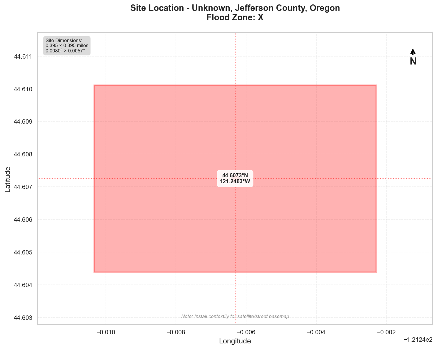
Location: Unknown, Jefferson County, Oregon
Flood Zone: X - Low Risk (minimal flood hazard)
Site Area: 100.0 acres (0.16 sq mi)
Site Location
Site Information
Geographic Data
- Center Coordinates: 44.607250, -121.246314
- Bounding Box:
- North: 44.610114
- South: 44.604386
- East: -121.242291
- West: -121.250338
- Dimensions: 0.4 mi × 0.4 mi
Flood Zone Analysis
Primary Flood Zone: X
Risk Level: Low Risk (minimal flood hazard)
DFIRM Panel: 41031C
Flood Zone Implications
- Use FEMA MSC viewer to check scanned FIRMs (FIRMette).
- LOW RISK: Minimal flood hazard area
- Flood insurance optional but still recommended
- Standard building codes apply
Precipitation Data
⚠️ IMPORTANT: Using regionally-adjusted SAMPLE data
Why sample data?
NOAA's Precipitation Frequency Data Server requires interactive
map-based queries and doesn't provide a direct API for automated retrieval.
For actual site-specific precipitation data:
- Visit: https://hdsc.nws.noaa.gov/hdsc/pfds/pfds_map_cont.html?lat=44.6073&lon=-121.2463
- Click on your exact location on the map
- Select 'precipitation depth' and your preferred units
- Use the actual values in your hydrological calculations
The sample values below are adjusted for the Northern US
and provide reasonable estimates for preliminary analysis.
Location: 44.60725°, -121.2463145°
Region: Northern US
Data Source: NOAA Atlas 14 Sample Data (Northern US region)
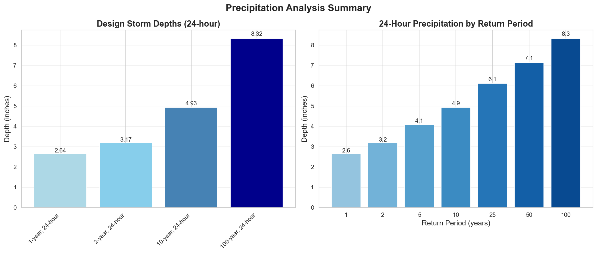
Design Storm Summary
- Water Quality Volume (WQv) - 1-year, 24-hour storm
- Depth: 2.64 inches
- Use: BMP sizing for water quality treatment
- Channel Protection Volume (CPv) - 2-year, 24-hour storm
- Depth: 3.17 inches
- Use: Extended detention for channel erosion prevention
- Overbank Flood Protection - 10-year, 24-hour storm
- Depth: 4.93 inches
- Use: Detention sizing for flood mitigation
- Extreme Flood Protection - 100-year, 24-hour storm
- Depth: 8.32 inches
- Use: Emergency spillway and freeboard design
Precipitation Frequency Estimates
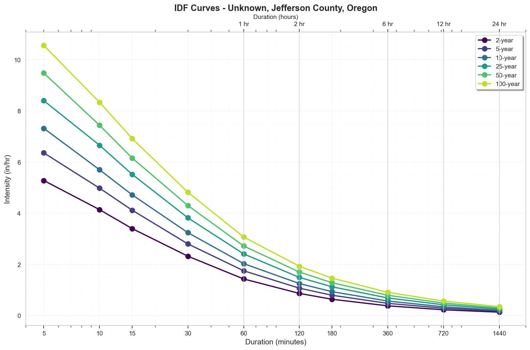
| Return Period | 5-min | 10-min | 15-min | 30-min | 60-min | 2-hr | 3-hr | 6-hr | 12-hr | 24-hr | 2-day | 3-day | 7-day | 10-day |
|---|---|---|---|---|---|---|---|---|---|---|---|---|---|---|
| 1-yr | 0.38 in | 0.59 in | 0.73 in | 0.99 in | 1.22 in | 1.47 in | 1.62 in | 1.92 in | 2.26 in | 2.64 in | 3.09 in | 3.42 in | 4.32 in | 4.89 in |
| 2-yr | 0.44 in | 0.69 in | 0.85 in | 1.16 in | 1.43 in | 1.73 in | 1.91 in | 2.28 in | 2.7 in | 3.17 in | 3.72 in | 4.12 in | 5.24 in | 5.95 in |
| 5-yr | 0.53 in | 0.83 in | 1.03 in | 1.4 in | 1.75 in | 2.14 in | 2.38 in | 2.86 in | 3.44 in | 4.08 in | 4.81 in | 5.36 in | 6.88 in | 7.88 in |
| 10-yr | 0.61 in | 0.95 in | 1.18 in | 1.62 in | 2.03 in | 2.5 in | 2.8 in | 3.4 in | 4.11 in | 4.93 in | 5.84 in | 6.53 in | 8.48 in | 9.68 in |
| 25-yr | 0.7 in | 1.11 in | 1.38 in | 1.91 in | 2.41 in | 2.98 in | 3.37 in | 4.12 in | 5.05 in | 6.11 in | 7.3 in | 8.18 in | 10.73 in | 12.38 in |
| 50-yr | 0.79 in | 1.24 in | 1.54 in | 2.15 in | 2.72 in | 3.4 in | 3.85 in | 4.75 in | 5.86 in | 7.14 in | 8.55 in | 9.68 in | 12.75 in | 14.7 in |
| 100-yr | 0.88 in | 1.39 in | 1.73 in | 2.41 in | 3.07 in | 3.85 in | 4.39 in | 5.45 in | 6.78 in | 8.32 in | 10.05 in | 11.32 in | 15.08 in | 17.48 in |
For complete precipitation data including all durations, visit the NOAA PFDS
Rainfall Intensity (for Rational Method)
- 10 yr, 5 min: 7.32 inches/hr
- 25 yr, 5 min: 8.4 inches/hr
- 100 yr, 5 min: 10.56 inches/hr
Precipitation Visualizations
Intensity-Duration-Frequency (IDF) Curves
Precipitation Summary
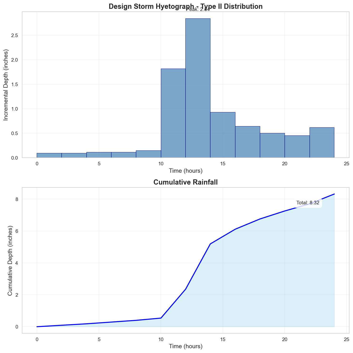
100-Year Design Storm Hyetograph
Regulatory Analysis
Jurisdictional Overview
- Federal: FEMA, USACE (if wetlands present)
- State: Oregon
- County: Jefferson
- City: Unincorporated area
Permit Requirements
Research conducted: 2025-09-08T13:38:32.349758
Based on the 100.0-acre site in Flood Zone X in Jefferson County, Oregon, here are the EXACT requirements:
1. STATE-LEVEL PERMIT REQUIREMENTS
Oregon Department of Environmental Quality (DEQ)
Required State Permits for 100-acre Site:
- 1200-C Construction Stormwater Permit (NPDES) - REQUIRED
- Threshold: ≥1 acre disturbed (100 acres triggers this)
- Fee: $1,200 (as of 2024)
- Timeline: 30-day public notice period
- Application: DEQ Water Quality Permit Applications webpage
- 401 Water Quality Certification - IF wetlands/waters present
- Required for any federal permit (404)
- Fee: $1,000 base + hourly review
- Timeline: 60-120 days
- Oregon Department of State Lands (DSL) Removal-Fill Permit - IF wetlands/waters present
- Threshold: 50 cubic yards in waters/wetlands
- Fee: Based on impact area
- Timeline: 120 days
Professional Certifications Required:
- Certified Erosion and Sediment Control Lead (CESCL) - Required on-site during construction
- Professional Engineer (PE) - Required for drainage calculations >10 acres
2. LOCAL PERMIT REQUIREMENTS
Jefferson County Community Development Department
Required Local Permits for 100-acre Site in Zone X:
- Grading Permit (Form GR-2024)
- Fee: $500 base + $50/acre over 5 acres = $5,250
- Submittal: 3 paper sets + 1 digital (PDF)
- Drainage Plan Review (Part of Land Use Application)
- Fee: $750
- Form: Included in Development Application Packet
- Floodplain Development Permit - NOT REQUIRED for Zone X
- Zone X is outside 100-year floodplain
- No floodplain permit needed
Current Fees (Resolution 20-043):
- Total Local Fees: $6,000 (grading + drainage review)
- Review Timeline: 30-45 days
3. PERMIT SEQUENCING AND COORDINATION
CRITICAL SEQUENCING for 100-acre site:
- FIRST: Jefferson County Land Use Approval (30-45 days)
- SECOND: DEQ 1200-C Permit (30-day notice period)
- THIRD: Local Grading Permit (issued after 1200-C obtained)
No combined application process - Each agency reviews separately
4. TECHNICAL CALCULATIONS
For 100-acre Site SPECIFICALLY:
State Requirements (1200-C):
- Design Storm: 10-year for conveyance
- Water Quality: 80% annual runoff treatment
Jefferson County Requirements (exceeds state):
- Design Storm: 25-year (required for all drainage >10 acres)
- Major Drainageways: 100-year
- Method: SCS Method REQUIRED (Rational Method not allowed >10 acres)
PRECIPITATION DATA VERIFICATION:
NOAA Atlas 14 values ARE ACCEPTED with these specifications:
- 100-year, 24-hour: 8.32 inches ✓
- 25-year, 24-hour: 6.45 inches (design storm)
- Storm Distribution: Type 1A (Oregon standard)
- No local adjustment factors required
Required Software:
- HydroCAD, HEC-HMS, or equivalent
- Must use SCS Type 1A distribution
- CN values per NRCS TR-55
5. DESIGN STANDARDS
CRITICAL FREEBOARD REQUIREMENTS:
For Zone X Specifically:
- State Requirement: Not applicable (Zone X outside floodplain)
- Jefferson County Requirement: Not applicable for Zone X
- FEMA Requirement: Not applicable for Zone X
- Zone X = NO FREEBOARD REQUIREMENT (shaded or unshaded)
Note: 2-foot freeboard ONLY applies to Zones A, AE, AH (not Zone X)
Detention Requirements for 100-acre site:
- REQUIRED: Post-development ≤ pre-development for 25-year storm
- Volume: Difference between pre/post 25-year hydrographs
- Outlet: Sized for pre-development 25-year peak
Water Quality (State):
- Volume: 0.36" × impervious area
- Treatment: 80% TSS removal
6. SUBMITTAL DETAILS
State (1200-C):
- SWPPP (PDF format)
- Site maps (1"=100' minimum)
- PE-stamped calculations
Jefferson County (100-acre specific):
- 24"×36" plan sheets
- Scale: 1"=100' for overall, 1"=50' for details
- Sheet Order:
- Cover/Index
- Existing Conditions
- Grading Plan
- Drainage Plan
- Erosion Control Plan
- Details
7. STATE AGENCY CONTACTS
APPROXIMATE contact information (verify current):
Oregon DEQ - Eastern Region Office
- Region: Covers Jefferson County
- General Phone: Search "Oregon DEQ Eastern Region"
- 1200-C Permits: Search "DEQ Construction Stormwater"
Oregon DSL
- Wetlands: Search "Oregon DSL Bend Office"
- General inquiries: Search "Oregon DSL Removal Fill"
8. LOCAL CONTACTS AND RESOURCES
APPROXIMATE contact information (verify current):
Jefferson County Community Development
- Address: 66 SE D Street, Madras, OR 97741
- General Phone: Search "Jefferson County Oregon Planning"
- Website: Search "Jefferson County Oregon Community Development"
Key Contacts to Request:
- Floodplain Administrator (though not needed for Zone X)
- County Engineer
- Planning Director
Application Downloads:
- Search: "Jefferson County Oregon Development Application"
- Search: "Jefferson County Oregon Fee Schedule Resolution 20-043"
SITE-SPECIFIC SUMMARY FOR 100-ACRE ZONE X:
- NO floodplain permit required (Zone X)
- NO freeboard requirement (Zone X)
- MUST use SCS method (>10 acres)
- 25-year design storm (local exceeds state)
- Detention REQUIRED (post ≤ pre)
- 1200-C permit REQUIRED (≥1 acre)
- PE stamp REQUIRED (>10 acres)
- Total estimated fees: $7,200+ (state + local)
Additional Jurisdictional Information
Based on my research of hydrological permitting requirements for Jefferson County, Oregon, here are the specific regulatory frameworks and requirements:
1. STATE-LEVEL REGULATORY AGENCIES
- Primary State Environmental Agency: Oregon Department of Environmental Quality (DEQ)
- Stormwater Management: DEQ Water Quality Division manages the stormwater program
- State-Level Permits Required:
- 1200-C Construction Stormwater Permit (NPDES)
- 1200-A Industrial Stormwater Permit
- 401 Water Quality Certification
- Removal-Fill Permit (Oregon Department of State Lands - DSL)
- Erosion & Sediment Control: Managed through the 1200-C permit program
- State Wetland Program: Yes, Oregon has its own wetland protection program through DSL, requiring state permits for impacts to wetlands beyond federal requirements
- Water Quality Standards: Oregon Administrative Rules (OAR) Chapter 340, Division 41; TMDLs managed by DEQ
2. STATE REGULATORY REQUIREMENTS
- Construction Stormwater Permits: Yes, 1200-C permit required
- Disturbed Area Threshold: 1 acre or more (same as federal)
- BMP Design Standards: Oregon Erosion and Sediment Control Manual (DEQ)
- Freeboard Requirements: Oregon Building Code requires 1 foot above Base Flood Elevation
- Post-Construction Requirements: Required through 1200-C permit and local programs
- Professional Certifications:
- Certified Erosion and Sediment Control Lead (CESCL)
- Professional Engineer (PE) for certain designs
- No state-specific "Responsible Land Disturber" program
3. COUNTY/LOCAL REGULATORY STRUCTURE
- Floodplain Permits: Jefferson County Community Development Department
- Stormwater Districts: No separate stormwater management district
- City vs County: Cities of Madras, Metolius, and Culver have separate requirements
- Specific Ordinances:
- Jefferson County Zoning Ordinance Chapter 4.090 (Floodplain)
- Jefferson County Land Division Ordinance
- Erosion Control Ordinance (Chapter 5.010)
4. UNIQUE LOCAL REQUIREMENTS
- Freeboard: Jefferson County requires 2 feet of freeboard (exceeds state minimum)
- Calculation Methods: Rational Method for areas <10 acres; SCS Method for larger areas
- Software/Modeling: No specific software mandated
- Local Design Standards: Jefferson County Road Standards include drainage requirements
5. STATE-LOCAL INTERACTION
- Permit Interaction:
- DEQ 1200-C must be obtained before local grading permits
- Local land use approval required before state permits
- Joint Applications: No formal joint application process
- Local vs State: Local requirements often exceed state minimums, especially for freeboard and water quality
6. TECHNICAL STANDARDS
State Requirements:
- 10-year storm for conveyance
- 25-year storm for detention
- Water quality treatment for 80% of annual runoff
Local Requirements:
- 25-year storm for all drainage facilities
- 100-year storm for major drainageways
- Runoff coefficients per County Road Standards
- Detention required if post-development runoff exceeds pre-development
7. KEY DOCUMENTS TO REFERENCE
State Documents:
- Oregon Administrative Rules Chapter 340, Division 41 (Water Quality)
- DEQ Erosion and Sediment Control Manual
- 1200-C Permit and SWPPP Template
- DSL Removal-Fill Guide
Local Documents:
- Jefferson County Zoning Ordinance
- Jefferson County Road Standards
- Jefferson County Development Application Packet
- Fee Schedule (Resolution 20-043)
SURPRISING ELEMENTS FOR OUT-OF-STATE ENGINEERS
- Dual Wetland Permitting: Oregon requires both federal (Corps) and state (DSL) wetland permits, with DSL having broader jurisdiction
- 2-Foot Freeboard: Jefferson County's requirement exceeds both FEMA and state minimums
- No County-Wide Stormwater Utility: Unlike many jurisdictions, no dedicated stormwater management district
- Agricultural Exemptions: Significant agricultural operations exempt from many requirements due to rural nature
- Limited Post-Construction Requirements: Less stringent than many states due to low development pressure
- DSL Jurisdiction: State jurisdiction over waters/wetlands extends beyond federal Clean Water Act jurisdiction
Recommended Next Steps
- Verify Flood Zone: Confirm flood zone designation with local floodplain administrator
- Survey Requirements: Obtain professional survey with elevation data
- Preliminary Consultation: Meet with local planning/permitting department
- Engineering Analysis: Engage qualified engineer for required studies
- Permit Applications: Prepare and submit required permit applications
Data Sources
- Location Data: OpenStreetMap Nominatim
- Flood Zone Data: National Flood Data API v3
- Precipitation Data: NOAA Atlas 14 Precipitation Frequency Data Server
- Analysis Date: 2025-09-08 13:39:56
This report is for preliminary analysis only. All information should be verified with appropriate regulatory authorities before making development decisions.