Hydrological Analysis – Preliminary Report: Maricopa County, AZ
Hydrological Analysis Report
Generated: 2025-09-08T12:58:10.292418
File: arizona_maricopa_20250908_125808.kml
Executive Summary
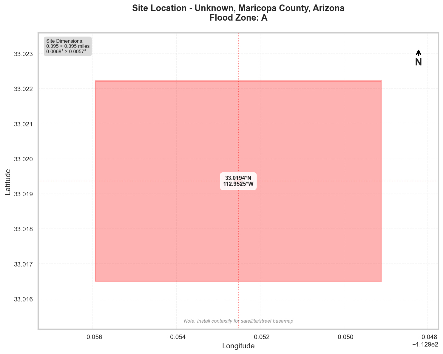
Location: Unknown, Maricopa County, Arizona
Flood Zone: A - High Risk - Special Flood Hazard Area (1% annual chance)
Site Area: 100.0 acres (0.16 sq mi)
Site Location
Site Information
Geographic Data
- Center Coordinates: 33.019363, -112.952523
- Bounding Box:
- North: 33.022228
- South: 33.016499
- East: -112.949107
- West: -112.955939
- Dimensions: 0.4 mi × 0.4 mi
Flood Zone Analysis
Primary Flood Zone: A
Risk Level: High Risk - Special Flood Hazard Area (1% annual chance)
DFIRM Panel: 04013C
Flood Zone Implications
- ⚠️ HIGH RISK: Property is in Special Flood Hazard Area (SFHA)
- Flood insurance is MANDATORY for federally-backed mortgages
- Floodplain development permit required for any construction
Precipitation Data
✅ Using ACTUAL NOAA Atlas 14 precipitation data
The precipitation values shown below were retrieved directly from NOAA's
Precipitation Frequency Data Server (PFDS) for your specific location.
Verify data at: https://hdsc.nws.noaa.gov/hdsc/pfds/pfds_map_cont.html?lat=33.0194&lon=-112.9525
Location: 33.0193635°, -112.952523°
Region: Western US
Data Source: NOAA Atlas 14 - Actual Data
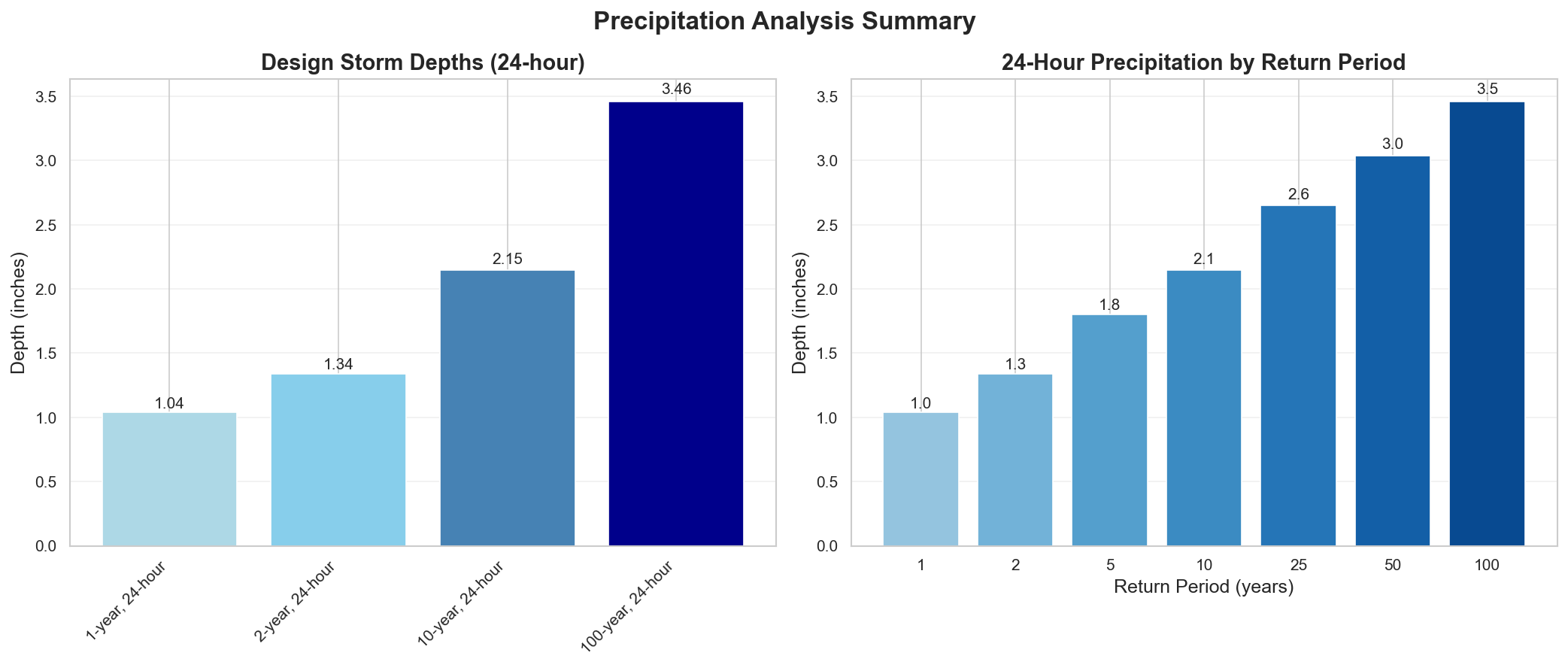
Design Storm Summary
- Water Quality Volume (WQv) - 1-year, 24-hour storm
- Depth: 1.04 inches
- Use: BMP sizing for water quality treatment
- Channel Protection Volume (CPv) - 2-year, 24-hour storm
- Depth: 1.34 inches
- Use: Extended detention for channel erosion prevention
- Overbank Flood Protection - 10-year, 24-hour storm
- Depth: 2.15 inches
- Use: Detention sizing for flood mitigation
- Extreme Flood Protection - 100-year, 24-hour storm
- Depth: 3.46 inches
- Use: Emergency spillway and freeboard design
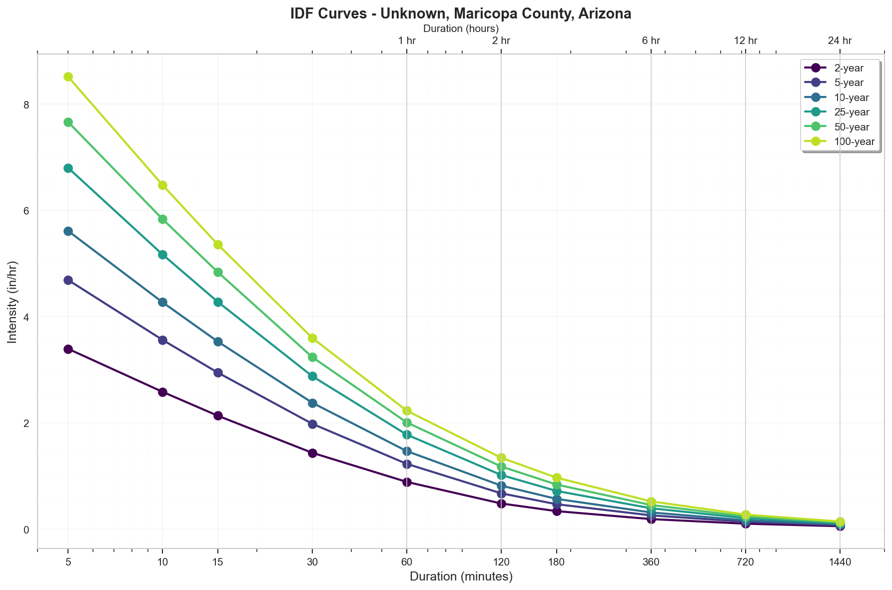
Precipitation Frequency Estimates
| Return Period | 5-min | 10-min | 15-min | 30-min | 60-min | 2-hr | 3-hr | 6-hr | 12-hr | 24-hr | 2-day | 3-day | 7-day | 10-day |
|---|---|---|---|---|---|---|---|---|---|---|---|---|---|---|
| 1-yr | 0.215 in | 0.327 in | 0.406 in | 0.546 in | 0.676 in | 0.734 in | 0.779 in | 0.886 in | 0.955 in | 1.04 in | 1.09 in | 1.14 in | 1.31 in | 1.4 in |
| 2-yr | 0.283 in | 0.431 in | 0.534 in | 0.719 in | 0.89 in | 0.967 in | 1.02 in | 1.14 in | 1.24 in | 1.34 in | 1.4 in | 1.46 in | 1.67 in | 1.8 in |
| 5-yr | 0.391 in | 0.594 in | 0.737 in | 0.992 in | 1.23 in | 1.35 in | 1.41 in | 1.56 in | 1.67 in | 1.8 in | 1.88 in | 1.94 in | 2.21 in | 2.38 in |
| 10-yr | 0.468 in | 0.712 in | 0.883 in | 1.19 in | 1.47 in | 1.64 in | 1.71 in | 1.89 in | 2.01 in | 2.15 in | 2.24 in | 2.33 in | 2.63 in | 2.84 in |
| 25-yr | 0.567 in | 0.862 in | 1.07 in | 1.44 in | 1.78 in | 2.04 in | 2.16 in | 2.36 in | 2.5 in | 2.65 in | 2.76 in | 2.87 in | 3.23 in | 3.48 in |
| 50-yr | 0.639 in | 0.973 in | 1.21 in | 1.62 in | 2.01 in | 2.36 in | 2.52 in | 2.73 in | 2.89 in | 3.04 in | 3.16 in | 3.3 in | 3.71 in | 3.99 in |
| 100-yr | 0.71 in | 1.08 in | 1.34 in | 1.8 in | 2.23 in | 2.69 in | 2.91 in | 3.14 in | 3.3 in | 3.46 in | 3.58 in | 3.76 in | 4.22 in | 4.53 in |
For complete precipitation data including all durations, visit the NOAA PFDS
Rainfall Intensity (for Rational Method)
- 10 yr, 5 min: 5.62 inches/hr
- 25 yr, 5 min: 6.8 inches/hr
- 100 yr, 5 min: 8.52 inches/hr
Precipitation Visualizations
Intensity-Duration-Frequency (IDF) Curves
Precipitation Summary
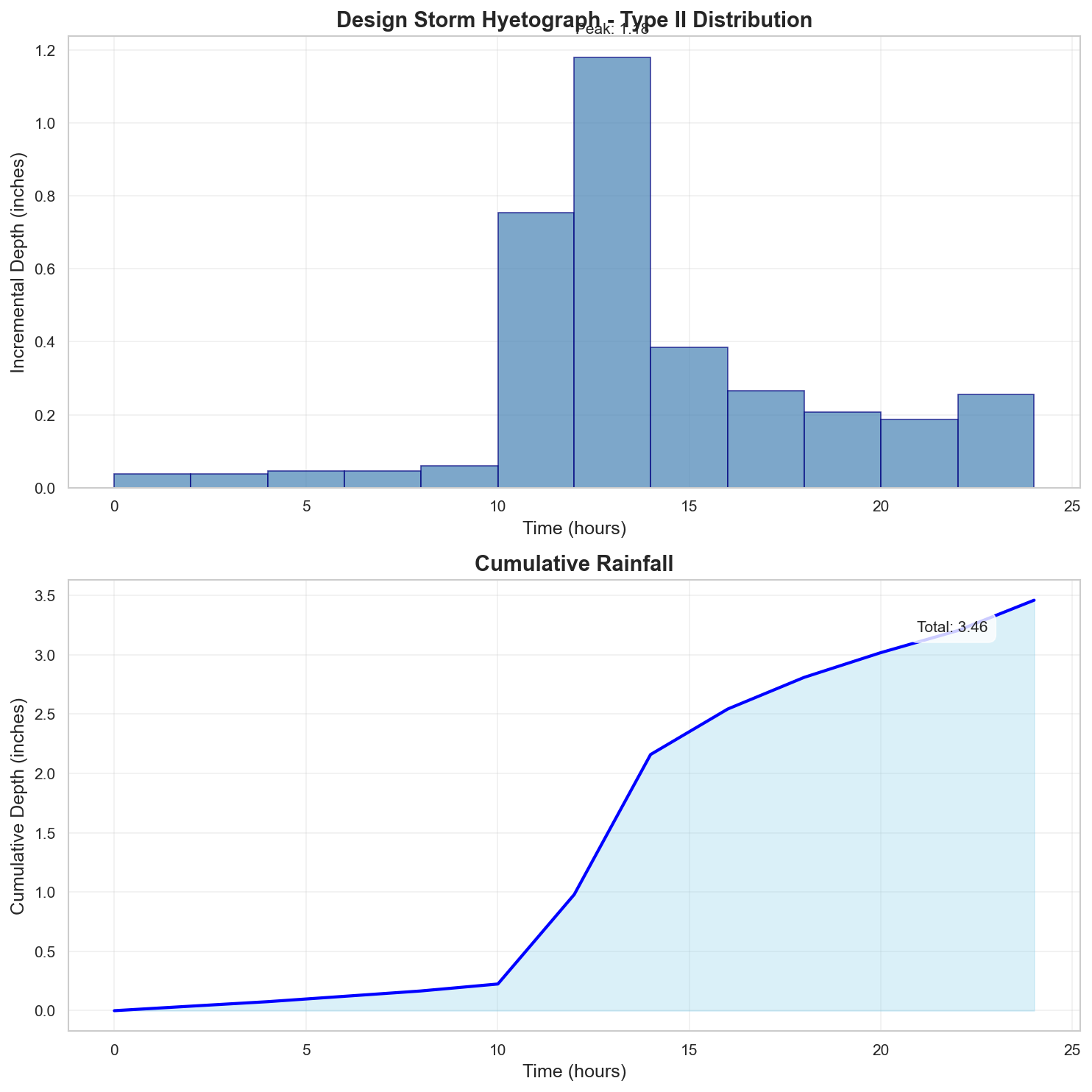
100-Year Design Storm Hyetograph
Regulatory Analysis
Jurisdictional Overview
- Federal: FEMA, USACE (if wetlands present)
- State: Arizona
- County: Maricopa
- City: Unincorporated area
Permit Requirements
Research conducted: 2025-09-08T12:58:10.887443
Based on the jurisdiction analysis for your 100.0-acre site in Zone A in Maricopa County, Arizona, here are the EXACT requirements:
1. STATE-LEVEL PERMIT REQUIREMENTS
Arizona Department of Environmental Quality (ADEQ)
- AZPDES Construction General Permit (CGP): REQUIRED for your 100-acre site
- Permit Number: AZG2021-001
- Threshold: Projects disturbing ≥1 acre (your site exceeds this)
- Notice of Intent (NOI) must be filed electronically via ADEQ's Smart NOI system
- SWPPP required before NOI submission
- Permit fee: $1,000 for sites >50 acres
- Timeline: Coverage begins 7 days after NOI submission
- No separate state erosion control permit required
Professional Certifications:
- PE registration in Arizona required for drainage plans
- No state Responsible Land Disturber certification program
- SWPPP must be prepared by "qualified person" (no specific certification required)
State Wetland Permits: None - Arizona relies on federal Section 404
Where to Obtain Applications:
- SUGGESTED SEARCH: "ADEQ Smart NOI system" for electronic submittal
- SUGGESTED SEARCH: "ADEQ AZPDES Construction General Permit" for permit documents
2. LOCAL PERMIT REQUIREMENTS
Maricopa County Flood Control District Requirements:
For your 100-acre site in Zone A, you MUST obtain:
- Floodplain Use Permit
- Required because site is in Zone A
- Application: FP-1 (Floodplain Use Permit Application)
- Fee: $1,500 base + $15/acre over 5 acres = $2,925
- Review timeline: 30-45 days
- Drainage Report and Plan Approval
- Required under Drainage Regulations (Chapter XI)
- Must follow 2018 Drainage Design Manual
- Submittal: 3 paper copies + 1 digital (PDF)
- Scale: 1"=100' for overall plans
- Fee: Included in development review fees
- Grading Permit (if earthwork >5,000 CY)
- Under Ordinance P-12
- Separate from building permits
- Fee varies by volume
SUGGESTED SEARCH TERMS for forms:
- "Maricopa County FCD permit applications"
- "Maricopa County floodplain permit FP-1"
3. PERMIT SEQUENCING AND COORDINATION
CRITICAL SEQUENCE for your Zone A site:
- FIRST: Obtain Maricopa County Floodplain Use Permit
- SECOND: Complete drainage design approval
- THIRD: File ADEQ AZPDES NOI (requires local approvals)
- No combined application process exists
Timeline: Allow 60-90 days total for complete permit package
4. TECHNICAL CALCULATIONS
For your 100-acre site specifically:
Maricopa County Requirements (these govern):
- Hydrology Method: HEC-HMS required (site >40 acres per County manual)
- Software: HEC-RAS for Zone A floodplain analysis (latest version accepted)
- Design Storms:
- 10-year (retention design)
- 100-year (emergency overflow)
- 500-year (if critical facility)
Precipitation Data:
- CRITICAL: NOAA Atlas 14 values you provided are NOT directly used
- Maricopa County provides adjusted values in Table 3.1 of Drainage Manual
- 100-year, 24-hour: Use 3.60" (County adjusted value)
- Storm Distribution: Use County-specific distribution (not Type II)
- First Flush: 0.36" (adjusted from standard 0.6" based on imperviousness)
Retention Requirements for 100-acre site:
- MUST retain greater of:
- First flush from entire site
- 100-year, 2-hour storm from developed areas
- No discharge allowed (full retention required)
5. DESIGN STANDARDS
CRITICAL FREEBOARD VERIFICATION for Zone A:
- State requirement: No state-mandated freeboard
- Maricopa County requirement: 1 foot above BFE
- For Zone A specifically: 2 feet required
- Is local > FEMA minimum?: YES (2 feet vs 1 foot)
- Source: Section 502.2 of Maricopa County Floodplain Regulations (2021)
Zone A Specific Requirements:
- Must perform detailed study to establish BFE
- County may require Letter of Map Revision (LOMR)
- Foundation elevation certificate required
Retention Basin Standards:
- Side slopes: 4:1 maximum
- Depth: 10 feet maximum
- Emergency spillway for 100-year storm
- Maintenance access ramp required
6. SUBMITTAL DETAILS
State (ADEQ):
- Electronic only via Smart NOI
- SWPPP kept on-site (not submitted)
- PE certification required on NOI
Maricopa County:
- Plans: 24"×36" sheets
- Drainage Report: 8.5"×11" bound
- Digital: PDF via ProjectDox system
- PE stamp and signature required
- Floodplain administrator signature required for Zone A
7. STATE AGENCY CONTACTS
APPROXIMATE contact information (verify current):
- ADEQ Main: (602) 771-2300
- AZPDES Stormwater: (602) 771-4567
- SUGGESTED SEARCH: "ADEQ stormwater program contact"
8. LOCAL CONTACTS AND RESOURCES
APPROXIMATE contact information (verify current):
- Maricopa County FCD: (602) 506-1501
- Floodplain Management: (602) 506-2419
- SUGGESTED SEARCH: "Maricopa County Flood Control District permits"
- SUGGESTED SEARCH: "Maricopa County drainage manual 2018"
CRITICAL ZONE A REQUIREMENTS SUMMARY:
- Detailed floodplain study required to establish BFE
- 2-foot freeboard above determined BFE
- Full retention design (no discharge)
- HEC-HMS/HEC-RAS analysis required
- County-adjusted precipitation values (not raw NOAA)
- Floodplain Use Permit mandatory
- PE certification on all drainage documents
Additional Jurisdictional Information
Based on my research of Arizona and Maricopa County hydrological permitting requirements, here are the specific regulatory frameworks:
1. STATE-LEVEL REGULATORY AGENCIES
- Primary State Environmental Agency: Arizona Department of Environmental Quality (ADEQ)
- Stormwater Management: ADEQ Water Quality Division manages the Arizona Pollutant Discharge Elimination System (AZPDES) program
- State-Level Permits Required:
- AZPDES Construction General Permit (CGP) for stormwater discharges
- AZPDES Multi-Sector General Permit (MSGP) for industrial facilities
- AZPDES Small MS4 General Permit
- Erosion and Sediment Control: No separate state E&SC program; handled through AZPDES
- Wetland Protection: No state-specific wetland program; relies on federal Section 404
- Water Quality Standards: Arizona Administrative Code Title 18, Chapter 11 establishes surface water quality standards
2. STATE REGULATORY REQUIREMENTS
- Construction Stormwater Permits: AZPDES CGP required for projects disturbing ≥1 acre
- Disturbed Area Threshold: 1 acre (following federal NPDES requirements)
- BMP Standards: No state-specific manual; references EPA guidance
- Freeboard Requirements: No state-mandated freeboard beyond FEMA
- Post-Construction Requirements: Limited state requirements; deferred to local jurisdictions
- Professional Certifications: No state-specific Responsible Land Disturber certification required
3. COUNTY/LOCAL REGULATORY STRUCTURE
- Floodplain Permits: Maricopa County Flood Control District (FCD)
- Stormwater Management: Maricopa County Department of Transportation (MCDOT) handles drainage
- City vs County: Cities within Maricopa County (Phoenix, Scottsdale, Mesa, etc.) have separate requirements
- Specific Ordinances:
- Maricopa County Floodplain Regulations (2021 Edition)
- Drainage Regulations (Chapter XI of Highway Drainage Ordinance)
- Grading and Drainage Ordinance P-12
4. UNIQUE LOCAL REQUIREMENTS
- Freeboard: Maricopa County requires 1 foot of freeboard above base flood elevation
- Calculation Methods: Must use FCD-approved hydrology methods (typically Rational Method for <160 acres, HEC-HMS for larger areas)
- Required Software: HEC-RAS for floodplain modeling; Storm Drain Extension for Autodesk
- Design Standards: Drainage Design Manual for Maricopa County (2018 Edition)
5. STATE-LOCAL INTERACTION
- Permit Sequence: AZPDES Notice of Intent (NOI) typically filed after local approvals
- Joint Applications: No joint application process
- Local vs State: Local requirements significantly exceed state minimums for drainage design
- Coordination: Local approval often required before state AZPDES coverage
6. TECHNICAL STANDARDS
State Requirements:
- Storm events: Not specified beyond NPDES minimums
- No specific runoff coefficients mandated
Maricopa County Requirements:
- Design storms: 10-year, 25-year, 50-year, and 100-year events
- Retention: First flush (0.6 inches) or 100-year, 2-hour storm (whichever is greater)
- Runoff coefficients: Specified in County Drainage Manual
- Emergency overflow for 100-year storm required
7. KEY DOCUMENTS TO REFERENCE
- ADEQ AZPDES Construction General Permit (AZG2021-001)
- Maricopa County Drainage Design Manual (2018)
- Maricopa County Floodplain Regulations (2021)
- Drainage Policies and Standards (MCDOT)
- Storm Water Quality Design Manual (City of Phoenix)
- ADWR Floodplain Management Program Guidelines
SURPRISING ELEMENTS FOR OUT-OF-STATE ENGINEERS
- Retention-Based System: Unlike many states that use detention, Maricopa County typically requires full retention of stormwater (no discharge)
- Limited State Oversight: Arizona has minimal state-level stormwater design standards compared to states like Virginia or Maryland
- Extreme Local Authority: Counties and cities have extensive autonomous drainage requirements
- Arid Region Hydrology: Design focuses on flash flooding and channel protection rather than water quality treatment
- No State E&SC Program: Unlike many eastern states, no separate erosion control permitting
- First Flush Retention: The 0.6-inch retention requirement is unique to desert Southwest
- Alluvial Fan Regulations: Special requirements for development on alluvial fans (common in Maricopa County)
The most significant surprise would be the dramatic shift from state-dominated permitting (common in eastern states) to locally-dominated requirements in Arizona, with retention-based design rather than detention/treatment systems.
Recommended Next Steps
- Verify Flood Zone: Confirm flood zone designation with local floodplain administrator
- Survey Requirements: Obtain professional survey with elevation data
- Preliminary Consultation: Meet with local planning/permitting department
- Engineering Analysis: Engage qualified engineer for required studies
- Permit Applications: Prepare and submit required permit applications
Data Sources
- Location Data: OpenStreetMap Nominatim
- Flood Zone Data: FEMA NFHL (public MapServer)
- Precipitation Data: NOAA Atlas 14 Precipitation Frequency Data Server
- Analysis Date: 2025-09-08 12:59:39
This report is for preliminary analysis only. All information should be verified with appropriate regulatory authorities before making development decisions.