Hydrological Analysis – Preliminary Report: Imperial County, CA
Hydrological Analysis Report
Generated: 2025-09-08T14:00:14.053008
File: california_imperial_20250908_140012.kml
Executive Summary
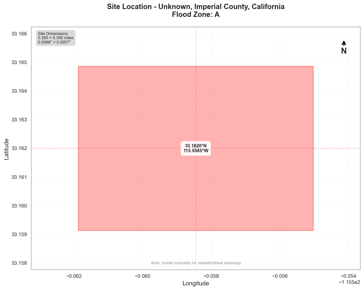
Location: Unknown, Imperial County, California
Flood Zone: A - High Risk - Special Flood Hazard Area (1% annual chance)
Site Area: 100.0 acres (0.16 sq mi)
Site Location
Site Information
Geographic Data
- Center Coordinates: 33.161991, -115.558451
- Bounding Box:
- North: 33.164855
- South: 33.159127
- East: -115.555029
- West: -115.561873
- Dimensions: 0.4 mi × 0.4 mi
Flood Zone Analysis
Primary Flood Zone: A
Risk Level: High Risk - Special Flood Hazard Area (1% annual chance)
DFIRM Panel: 06025C
Flood Zone Implications
- ⚠️ HIGH RISK: Property is in Special Flood Hazard Area (SFHA)
- Flood insurance is MANDATORY for federally-backed mortgages
- Floodplain development permit required for any construction
Precipitation Data
✅ Using ACTUAL NOAA Atlas 14 precipitation data
The precipitation values shown below were retrieved directly from NOAA's
Precipitation Frequency Data Server (PFDS) for your specific location.
Verify data at: https://hdsc.nws.noaa.gov/hdsc/pfds/pfds_map_cont.html?lat=33.1620&lon=-115.5585
Location: 33.161991°, -115.558451°
Region: Western US
Data Source: NOAA Atlas 14 - Actual Data
Design Storm Summary
- Water Quality Volume (WQv) - 1-year, 24-hour storm
- Depth: 0.634 inches
- Use: BMP sizing for water quality treatment
- Channel Protection Volume (CPv) - 2-year, 24-hour storm
- Depth: 0.951 inches
- Use: Extended detention for channel erosion prevention
- Overbank Flood Protection - 10-year, 24-hour storm
- Depth: 1.84 inches
- Use: Detention sizing for flood mitigation
- Extreme Flood Protection - 100-year, 24-hour storm
- Depth: 3.67 inches
- Use: Emergency spillway and freeboard design
Precipitation Frequency Estimates
| Return Period | 5-min | 10-min | 15-min | 30-min | 60-min | 2-hr | 3-hr | 6-hr | 12-hr | 24-hr | 2-day | 3-day | 7-day | 10-day |
|---|---|---|---|---|---|---|---|---|---|---|---|---|---|---|
| 1-yr | 0.06 in | 0.086 in | 0.104 in | 0.146 in | 0.203 in | 0.281 in | 0.329 in | 0.417 in | 0.497 in | 0.634 in | 0.72 in | 0.761 in | 0.847 in | 0.866 in |
| 2-yr | 0.095 in | 0.136 in | 0.164 in | 0.23 in | 0.319 in | 0.424 in | 0.488 in | 0.612 in | 0.735 in | 0.951 in | 1.09 in | 1.16 in | 1.28 in | 1.32 in |
| 5-yr | 0.148 in | 0.211 in | 0.256 in | 0.358 in | 0.497 in | 0.64 in | 0.728 in | 0.902 in | 1.09 in | 1.42 in | 1.63 in | 1.74 in | 1.92 in | 1.97 in |
| 10-yr | 0.197 in | 0.282 in | 0.342 in | 0.478 in | 0.664 in | 0.84 in | 0.949 in | 1.17 in | 1.41 in | 1.84 in | 2.12 in | 2.25 in | 2.49 in | 2.55 in |
| 25-yr | 0.276 in | 0.395 in | 0.478 in | 0.669 in | 0.929 in | 1.16 in | 1.3 in | 1.58 in | 1.9 in | 2.49 in | 2.85 in | 3.02 in | 3.34 in | 3.41 in |
| 50-yr | 0.347 in | 0.497 in | 0.601 in | 0.84 in | 1.17 in | 1.44 in | 1.6 in | 1.94 in | 2.33 in | 3.04 in | 3.48 in | 3.68 in | 4.05 in | 4.14 in |
| 100-yr | 0.429 in | 0.615 in | 0.744 in | 1.04 in | 1.44 in | 1.76 in | 1.95 in | 2.35 in | 2.82 in | 3.67 in | 4.18 in | 4.41 in | 4.84 in | 4.95 in |
For complete precipitation data including all durations, visit the NOAA PFDS
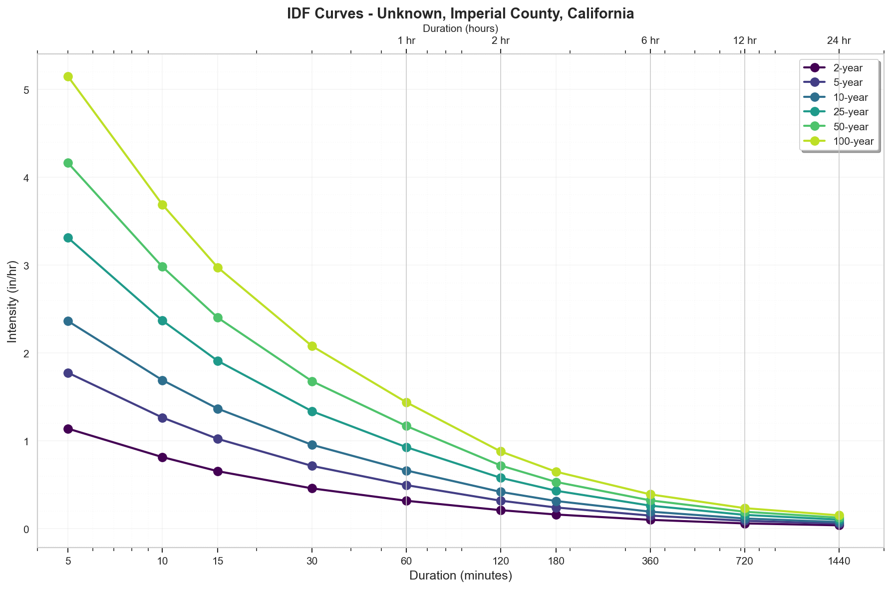
Rainfall Intensity (for Rational Method)
- 10 yr, 5 min: 2.36 inches/hr
- 25 yr, 5 min: 3.31 inches/hr
- 100 yr, 5 min: 5.15 inches/hr
Precipitation Visualizations
Intensity-Duration-Frequency (IDF) Curves
Precipitation Summary
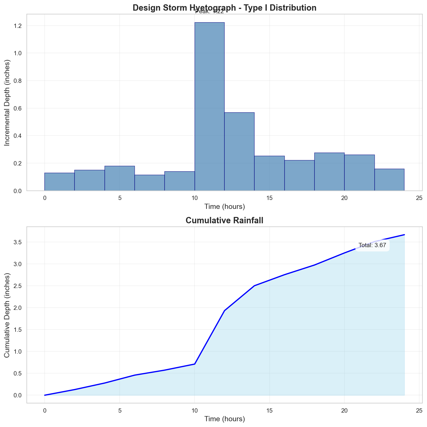
100-Year Design Storm Hyetograph
Regulatory Analysis
Jurisdictional Overview
- Federal: FEMA, USACE (if wetlands present)
- State: California
- County: Imperial
- City: Unincorporated area
Permit Requirements
Research conducted: 2025-09-08T14:00:14.630394
Based on the jurisdiction analysis for Imperial County, California, here are the EXACT requirements for your 100.0-acre site in Flood Zone A:
1. STATE-LEVEL PERMIT REQUIREMENTS
Primary State Environmental Agency:
- California State Water Resources Control Board (SWRCB)
- Regional Water Quality Control Board, Region 7 (Colorado River Basin)
Required State Permits for 100-acre Site:
- Construction General Permit (CGP)
- REQUIRED: Site exceeds 1-acre threshold
- Order No. 2009-0009-DWQ as amended by 2010-0014-DWQ and 2012-0006-DWQ
- Risk Level Determination Required (likely Risk Level 2 based on size)
- Application: Through SMARTS online system
- Timeline: 14 days after NOI submission before commencing construction
- Fee: $3,744 (Risk Level 2) + $490 annual fee
- 401 Water Quality Certification
- REQUIRED if impacting Waters of the State
- Application through Regional Board Region 7
- Timeline: 60-day review period
Professional Certifications Required:
- Qualified SWPPP Developer (QSD) - must prepare SWPPP
- Qualified SWPPP Practitioner (QSP) - must implement SWPPP
- Professional Engineer (PE) for drainage calculations
State Permit Applications:
- SMARTS System: https://smarts.waterboards.ca.gov
- Regional Board 7: 73-720 Fred Waring Drive, Suite 100, Palm Desert, CA 92260
- Phone: (760) 346-7491
2. LOCAL PERMIT REQUIREMENTS
Required Imperial County Permits:
- Floodplain Development Permit
- REQUIRED: Site is in Zone A
- Form: Available at Public Works Department
- Imperial County Code Title 9, Division 14
- Grading Permit
- REQUIRED: Exceeds 5,000 cubic yards or 5 acres
- Form Number: Contact Public Works for current form
- Imperial County Code Title 9, Division 16
- Building Permits (for any structures)
- Imperial County Building Department
Submittal Requirements:
- 3 sets of plans (24"x36" minimum)
- Digital submittal in PDF format
- Engineer's calculations sealed by California PE
- SWPPP copy
- Drainage study
Current Fees (verify with County):
- Floodplain Development Permit: ~$500-1,000
- Grading Permit: Based on volume, expect $5,000+
- Plan Check Fees: Additional percentage of permit fees
Review Timeline:
- Initial review: 30 days
- Resubmittal reviews: 14 days
3. PERMIT SEQUENCING AND COORDINATION
Required Sequence:
- CEQA compliance determination
- State CGP through SMARTS (concurrent with local)
- County Floodplain Development Permit
- County Grading Permit
- Building Permits (if applicable)
- IID Encroachment Permit (if near IID facilities)
Coordination:
- No combined application process
- County reviews state SWPPP compliance
- Total timeline: 60-90 days minimum
4. TECHNICAL CALCULATIONS
State Requirements:
- Water Quality Volume: 85th percentile, 24-hour storm
- Use CASQA BMP Sizing Calculator or equivalent
Imperial County Requirements:
- Design Storm: 100-year event for major drainage
- Method: Rational Method acceptable for 100 acres
- Software: HEC-HMS, HEC-RAS accepted
- Time of Concentration: SCS Method
CRITICAL RAINFALL DATA VERIFICATION:
- NOAA Atlas 14 values ARE accepted by Imperial County
- 100-year, 24-hour: 3.67 inches (CONFIRMED)
- Use Type I storm distribution
- No local adjustment factors required
Runoff Coefficients:
- Undeveloped desert: 0.10-0.30
- Developed areas: Per County Standards Table
5. DESIGN STANDARDS
State BMP Requirements:
- CASQA BMP Handbooks (current edition)
- Post-construction BMPs required
- LID prioritization mandatory
CRITICAL FREEBOARD REQUIREMENTS:
- State requirement: 1 foot minimum above BFE
- Imperial County requirement: 2 feet above BFE
- For Zone A specifically: 2 feet (County exceeds FEMA)
- County requirement is GREATER than FEMA minimum: YES
- Source: Imperial County Code Title 9, Division 14, Section 9.14.060
Detention Requirements:
- Post-development discharge ≤ pre-development
- Retention preferred due to limited outfalls
- Emergency spillway required
Foundation Requirements:
- Elevation Certificate required
- Lowest floor 2 feet above BFE
- FEMA Elevation Certificate by licensed surveyor
6. SUBMITTAL DETAILS
State Submittal:
- Electronic only through SMARTS
- PE certification required
- QSD signature on SWPPP
County Submittal:
- Plan sheets in order: Cover, Existing Conditions, Grading, Drainage, Erosion Control, Details
- PE wet stamp and signature
- Digital PDF required
- Calculations in 8.5"x11" format
7. STATE AGENCY CONTACTS
IMPORTANT: Contact information should be verified as it may change
State Water Resources Control Board:
- Main: (916) 341-5250
- Website: www.waterboards.ca.gov
Regional Board 7 (Colorado River Basin):
- SUGGESTED CONTACT: (760) 346-7491
- Address: 73-720 Fred Waring Drive, Suite 100, Palm Desert, CA 92260
- VERIFY current stormwater program manager
8. LOCAL CONTACTS AND RESOURCES
IMPORTANT: Verify all contact information as it changes frequently
Imperial County Public Works:
- SUGGESTED: (442) 265-1818
- Floodplain Administrator: Contact Public Works for current person
- Address: 155 South 11th Street, El Centro, CA 92243
Imperial County Planning & Development Services:
- SUGGESTED: (442) 265-1736
- Website: www.icpds.com
Imperial Irrigation District:
- Engineering: (760) 339-9228
- Encroachment Permits: Engineering Department
CRITICAL VERIFICATION NEEDED:
- All phone numbers and emails should be verified before use
- Fee schedules change annually
- Contact names change with staff turnover
Key Resources:
- Imperial County website: www.co.imperial.ca.us
- Search "Floodplain Development Permit" for current forms
- Search "Grading Ordinance" for current standards
Additional Jurisdictional Information
HYDROLOGICAL PERMITTING REQUIREMENTS - IMPERIAL COUNTY, CALIFORNIA
1. STATE-LEVEL REGULATORY AGENCIES
Primary State Environmental Agency:
- California Environmental Protection Agency (CalEPA)
- State Water Resources Control Board (SWRCB) - primary water quality authority
- Regional Water Quality Control Board, Region 7 (Colorado River Basin) - covers Imperial County
Stormwater Management Program:
- California has a comprehensive statewide stormwater program administered by SWRCB
- National Pollutant Discharge Elimination System (NPDES) program delegated to California
State-Level Permits Required:
- Construction General Permit (CGP) - Order No. 2009-0009-DWQ as amended
- Industrial General Permit (IGP) for industrial facilities
- MS4 Permits (Municipal Separate Storm Sewer System)
- 401 Water Quality Certification
- Waste Discharge Requirements (WDRs) for non-federal waters
Erosion and Sediment Control:
- Required through the Construction General Permit
- Must prepare and implement a Storm Water Pollution Prevention Plan (SWPPP)
State Wetland Protection:
- Porter-Cologne Water Quality Control Act provides broader protection than federal Clean Water Act
- Covers "Waters of the State" including isolated wetlands not covered federally
2. STATE REGULATORY REQUIREMENTS
Construction Stormwater Permits:
- Required for projects disturbing 1 acre or more
- Linear projects: 1 acre or more of disturbed area
- Risk-based approach with three risk levels (1, 2, and 3)
BMP Design Standards:
- California Stormwater Quality Association (CASQA) BMP Handbooks
- Caltrans Stormwater Quality Handbooks for transportation projects
Post-Construction Requirements:
- Mandatory post-construction stormwater management requirements
- Low Impact Development (LID) prioritization
- Hydromodification management requirements in some areas
Professional Certifications:
- Qualified SWPPP Developer (QSD)
- Qualified SWPPP Practitioner (QSP)
- Professional Engineer (PE) for certain designs
3. COUNTY/LOCAL REGULATORY STRUCTURE
Imperial County Departments:
- Imperial County Public Works Department - Floodplain Management
- Imperial County Planning & Development Services Department
- Imperial County Air Pollution Control District (dust control requirements)
Specific Ordinances:
- Imperial County Code Title 9, Division 14 - Floodplain Management Ordinance
- Imperial County Code Title 9, Division 16 - Grading Ordinance
- Imperial County Stormwater Management Plan (as MS4 permittee)
Imperial Irrigation District (IID):
- Major regional entity controlling water delivery and drainage
- Encroachment permits required for work near IID facilities
4. UNIQUE LOCAL REQUIREMENTS
Imperial County Specific Requirements:
- Desert environment considerations - emphasis on dust control
- Agricultural drainage considerations due to extensive farming
- Salton Sea proximity impacts for northern county projects
- IID coordination required for most drainage projects
Calculation Methods:
- Rational Method typically used for areas under 640 acres
- Must account for agricultural return flows
- Special considerations for New and Alamo Rivers
Design Standards:
- Imperial County Improvement Standards and Specifications
- Coordination with IID Drainage Design Manual
5. STATE-LOCAL INTERACTION
Permit Sequencing:
- CEQA compliance (state level)
- State Water Board permits (CGP, 401 Cert)
- County grading and building permits
- IID encroachment permits if applicable
Overlapping Requirements:
- County requirements generally meet or exceed state minimums
- Both require SWPPP implementation
- County enforces state water quality standards locally
6. TECHNICAL STANDARDS
State Requirements:
- 85th percentile, 24-hour storm for water quality treatment
- Risk Level 2 & 3 sites: additional numeric effluent limitations
- pH range: 6.5-8.5
- Turbidity limits based on risk level
Imperial County Standards:
- 100-year storm event for major drainage facilities
- 10-year storm for local drainage
- Special considerations for closed basin hydrology
- Retention/detention often required due to limited outfall options
Unique Considerations:
- High evaporation rates affect pond sizing
- Shallow groundwater in many areas
- High salinity considerations
- Seismic design requirements for retention structures
7. KEY DOCUMENTS TO REFERENCE
State Documents:
- Construction General Permit Order 2009-0009-DWQ
- CASQA BMP Handbooks
- SWRCB SMARTS database requirements
Local Documents:
- Imperial County Improvement Standards and Specifications
- Imperial County Floodplain Management Ordinance
- Imperial County MS4 Permit and SWMP
- IID Water Department Engineering Standards
- Imperial County CEQA Guidelines
SURPRISING ELEMENTS FOR OUT-OF-STATE ENGINEERS:
- Dual Water Systems: The prominence of IID as a quasi-governmental entity controlling both irrigation water and drainage
- Desert Hydrology: Extreme evaporation rates and rare but intense rainfall events
- Agricultural Interface: Extensive tile drain systems and agricultural return flows affecting project drainage
- Salton Sea Influence: Declining sea levels creating new drainage challenges
- CEQA Process: California's additional environmental review beyond NEPA
- Risk-Based Permitting: CGP's three-tier risk system unique to California
- Waters of the State: Broader jurisdiction than federal Clean Water Act
- Numeric Effluent Limitations: Specific turbidity limits for construction sites
- QSD/QSP Requirements: Mandatory certifications for SWPPP preparers and implementers
- Post-Construction Requirements: Extensive LID and hydromodification control requirements at state level
Recommended Next Steps
- Verify Flood Zone: Confirm flood zone designation with local floodplain administrator
- Survey Requirements: Obtain professional survey with elevation data
- Preliminary Consultation: Meet with local planning/permitting department
- Engineering Analysis: Engage qualified engineer for required studies
- Permit Applications: Prepare and submit required permit applications
Data Sources
- Location Data: OpenStreetMap Nominatim
- Flood Zone Data: FEMA NFHL (public MapServer)
- Precipitation Data: NOAA Atlas 14 Precipitation Frequency Data Server
- Analysis Date: 2025-09-08 14:01:52
This report is for preliminary analysis only. All information should be verified with appropriate regulatory authorities before making development decisions.