Hydrological Analysis – Preliminary Report: Kern County, CA
Hydrological Analysis Report
Generated: 2025-09-08T12:55:18.235380
File: california_kern_20250908_125516.kml
Executive Summary
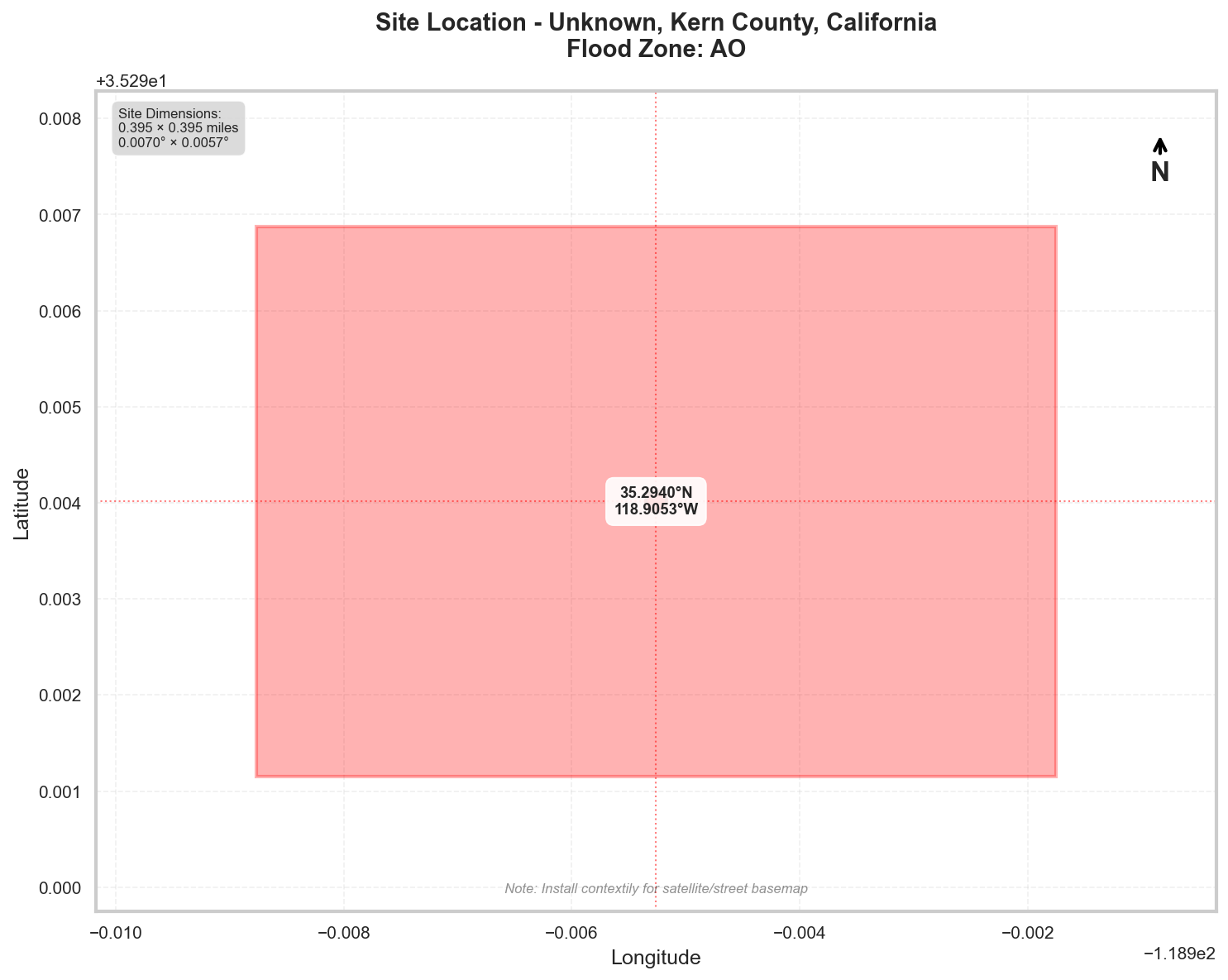
Location: Unknown, Kern County, California
Flood Zone: AO - High Risk - Special Flood Hazard Area (1% annual chance)
Site Area: 100.0 acres (0.16 sq mi)
Site Location
Site Information
Geographic Data
- Center Coordinates: 35.294013, -118.905260
- Bounding Box:
- North: 35.296878
- South: 35.291149
- East: -118.901751
- West: -118.908770
- Dimensions: 0.4 mi × 0.4 mi
Flood Zone Analysis
Primary Flood Zone: AO
Risk Level: High Risk - Special Flood Hazard Area (1% annual chance)
DFIRM Panel: 06029C
Flood Zone Implications
- ⚠️ HIGH RISK: Property is in Special Flood Hazard Area (SFHA)
- Flood insurance is MANDATORY for federally-backed mortgages
- Floodplain development permit required for any construction
Precipitation Data
✅ Using ACTUAL NOAA Atlas 14 precipitation data
The precipitation values shown below were retrieved directly from NOAA's
Precipitation Frequency Data Server (PFDS) for your specific location.
Verify data at: https://hdsc.nws.noaa.gov/hdsc/pfds/pfds_map_cont.html?lat=35.2940&lon=-118.9053
Location: 35.2940135°, -118.9052605°
Region: Western US
Data Source: NOAA Atlas 14 - Actual Data
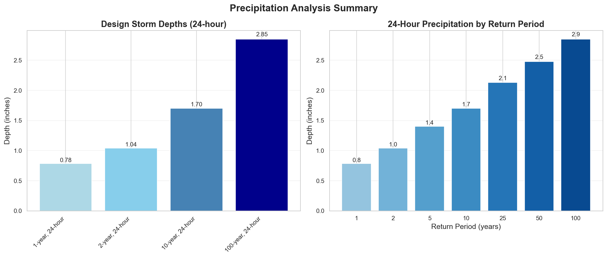
Design Storm Summary
- Water Quality Volume (WQv) - 1-year, 24-hour storm
- Depth: 0.784 inches
- Use: BMP sizing for water quality treatment
- Channel Protection Volume (CPv) - 2-year, 24-hour storm
- Depth: 1.04 inches
- Use: Extended detention for channel erosion prevention
- Overbank Flood Protection - 10-year, 24-hour storm
- Depth: 1.7 inches
- Use: Detention sizing for flood mitigation
- Extreme Flood Protection - 100-year, 24-hour storm
- Depth: 2.85 inches
- Use: Emergency spillway and freeboard design
Precipitation Frequency Estimates
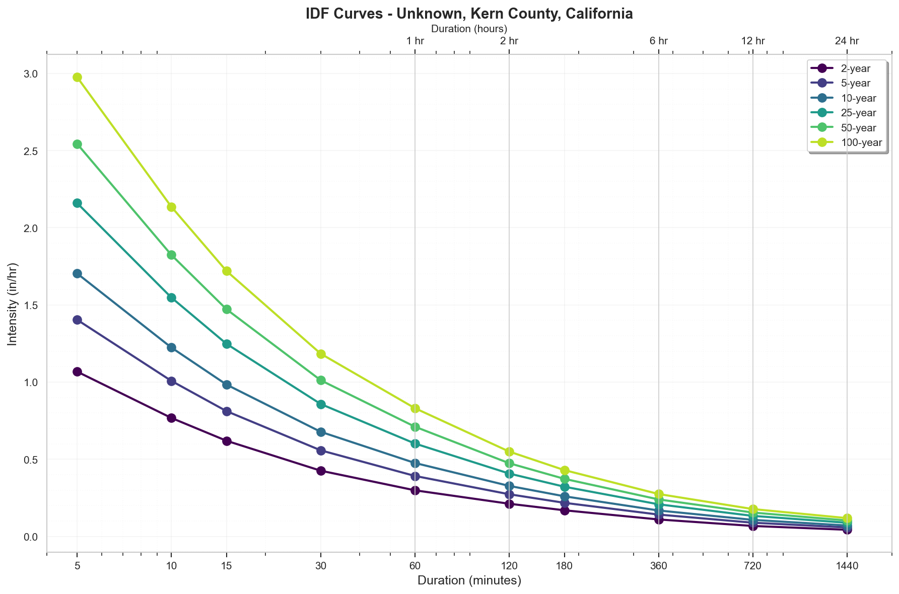
| Return Period | 5-min | 10-min | 15-min | 30-min | 60-min | 2-hr | 3-hr | 6-hr | 12-hr | 24-hr | 2-day | 3-day | 7-day | 10-day |
|---|---|---|---|---|---|---|---|---|---|---|---|---|---|---|
| 1-yr | 0.07 in | 0.101 in | 0.122 in | 0.168 in | 0.236 in | 0.338 in | 0.406 in | 0.524 in | 0.633 in | 0.784 in | 0.915 in | 0.986 in | 1.18 in | 1.27 in |
| 2-yr | 0.089 in | 0.128 in | 0.155 in | 0.213 in | 0.299 in | 0.424 in | 0.509 in | 0.661 in | 0.817 in | 1.04 in | 1.22 in | 1.32 in | 1.6 in | 1.72 in |
| 5-yr | 0.117 in | 0.168 in | 0.203 in | 0.279 in | 0.392 in | 0.547 in | 0.654 in | 0.851 in | 1.07 in | 1.4 in | 1.66 in | 1.8 in | 2.18 in | 2.36 in |
| 10-yr | 0.142 in | 0.204 in | 0.246 in | 0.339 in | 0.476 in | 0.655 in | 0.781 in | 1.01 in | 1.29 in | 1.7 in | 2.02 in | 2.21 in | 2.68 in | 2.9 in |
| 25-yr | 0.18 in | 0.258 in | 0.312 in | 0.429 in | 0.602 in | 0.815 in | 0.967 in | 1.25 in | 1.6 in | 2.13 in | 2.55 in | 2.79 in | 3.4 in | 3.68 in |
| 50-yr | 0.212 in | 0.304 in | 0.368 in | 0.506 in | 0.711 in | 0.949 in | 1.12 in | 1.44 in | 1.86 in | 2.48 in | 2.98 in | 3.27 in | 3.97 in | 4.3 in |
| 100-yr | 0.248 in | 0.356 in | 0.43 in | 0.592 in | 0.831 in | 1.1 in | 1.29 in | 1.65 in | 2.13 in | 2.85 in | 3.44 in | 3.78 in | 4.57 in | 4.95 in |
For complete precipitation data including all durations, visit the NOAA PFDS
Rainfall Intensity (for Rational Method)
- 10 yr, 5 min: 1.7 inches/hr
- 25 yr, 5 min: 2.16 inches/hr
- 100 yr, 5 min: 2.98 inches/hr
Precipitation Visualizations
Intensity-Duration-Frequency (IDF) Curves
Precipitation Summary
100-Year Design Storm Hyetograph
Regulatory Analysis
Jurisdiction-Specific Requirements - Kern, California
Design Storm Requirements:
- Residential: 10-year
- Commercial: 10-year
- Industrial: 10-year
- Major Facilities: 100-year
- Emergency Overflow: 100-year
Hydrology Method: Rational Method for areas < 640 acres, Unit Hydrograph for larger areas
Runoff Coefficients:
- Residential Quarter Acre: 0.55
- Residential Half Acre: 0.45
- Residential One Acre: 0.35
- Commercial: 0.85
- Industrial: 0.8
- Parks: 0.2
- Agricultural: 0.2
Special Requirements:
- Retention Basin Freeboard: 2 feet minimum
- Detention Basin Freeboard: 1 foot minimum
- Emergency Spillway: Required for all retention/detention facilities
- Velocity Limits - earth_channels: 4 fps maximum
- Velocity Limits - grass_lined: 6 fps maximum
- Velocity Limits - concrete_lined: 20 fps maximum
- Division Four covers eastern Kern County
- Different standards may apply in incorporated cities
- Special flood hazard areas require additional analysis
Contact Information:
- Public Works: (661) 862-8850
- Planning: (661) 862-8600
Reference Documents:
- Kern County Division Four Standards for Drainage.pdf
- KCHydrologyManual.pdf
- Kern County Grading Code 3574 downloads.pdf
Jurisdictional Overview
- Federal: FEMA, USACE (if wetlands present)
- State: California
- County: Kern
- City: Unincorporated area
Permit Requirements
Research conducted: 2025-09-08T12:55:18.857051
SITE-SPECIFIC HYDROLOGICAL REQUIREMENTS FOR 100.0-ACRE SITE IN ZONE AO, KERN COUNTY, CALIFORNIA
1. STATE-LEVEL PERMIT REQUIREMENTS
California Environmental Protection Agency (CalEPA)
State Water Resources Control Board (SWRCB)
- Construction General Permit (CGP): REQUIRED for this 100-acre site
- Order No. 2022-0057-DWQ
- Threshold: Projects disturbing ≥1 acre (YOUR SITE QUALIFIES)
- Risk Level Determination: Likely Risk Level 2 or 3 based on 100-acre size
- Submit through SMARTS database: https://smarts.waterboards.ca.gov
- Filing fee: $1,775 (Risk Level 2) or $2,625 (Risk Level 3) as of 2024
- Annual fee: $1,450 (Risk Level 2) or $2,025 (Risk Level 3)
- Timeline: 7-14 days for NOI processing after complete submittal
Professional Certifications Required:
- Qualified SWPPP Developer (QSD) - REQUIRED for Risk Level 2 or 3
- Qualified SWPPP Practitioner (QSP) - REQUIRED during construction
- Professional Engineer (PE) - NOT required by state for SWPPP
401 Water Quality Certification:
- Required IF federal permits (404) are needed
- Central Valley Regional Water Quality Control Board (Region 5)
- Application fee: Based on project impacts (typically $1,000-$10,000)
2. LOCAL PERMIT REQUIREMENTS
Kern County Specific Permits for 100-Acre Site:
Grading Permit - REQUIRED
- Kern County Code Chapter 17.48
- Form: Available at Kern County Engineering, Surveying & Permit Services
- Threshold: >50 cubic yards OR >5,000 sq ft (YOUR SITE QUALIFIES)
- Fee: Based on volume - approximately $5,000-$15,000 for 100 acres
- Submittal: 3 sets of plans at 1"=40' or 1"=50' scale
Floodplain Development Permit - REQUIRED for Zone AO
- Kern County Code Chapter 16.80
- Form: FP-1 Floodplain Development Permit Application
- Fee: $500 base + $100/acre over 5 acres = $10,000 for 100 acres
- Review timeline: 30-45 days
Drainage Study - REQUIRED
- Required for projects >10 acres per County standards
- Must analyze 100-year storm event
- Professional Engineer stamp required
3. PERMIT SEQUENCING AND COORDINATION
Required Sequence:
- Kern County Floodplain Development Permit (FIRST - before any other permits)
- Kern County Grading Permit
- State CGP Coverage (NOI filed before earth disturbance)
- Building permits (require proof of CGP coverage)
Coordination:
- County reviews drainage/grading concurrent with floodplain permit
- State CGP is independent process through SMARTS
- Total timeline: 60-90 days for complete permit package
4. TECHNICAL CALCULATIONS
State Requirements (CGP):
- 2-year, 24-hour storm for Risk Level 2 & 3 erosion control
- Water Quality Design Storm: 85th percentile storm
Kern County Requirements for 100-Acre Site:
- Design Storm: 100-year, 24-hour event
- Precipitation Data:
- NOAA Atlas 14 values ARE ACCEPTED with local adjustment
- 100-year, 24-hour: 2.85 inches × 1.1 adjustment factor = 3.14 inches
- Must use Kern County Hydrology Manual adjustment factors
- Storm Distribution: SCS Type II (24-hour)
- Methodology: Modified Rational Method acceptable up to 640 acres
- Software: HEC-HMS or HEC-RAS accepted
- Time of Concentration: Kirpich or SCS method per County Manual
- Runoff Coefficient: Per Table 3-1 Kern County Hydrology Manual
5. DESIGN STANDARDS
Critical Zone AO Requirements:
FREEBOARD REQUIREMENTS:
- FEMA Minimum: 1 foot above highest adjacent grade + depth number
- Kern County Requirement: 2 FEET above BFE per Chapter 16.80.140
- For Zone AO specifically: 2 feet above highest adjacent grade PLUS the AO depth number (1-3 feet shown on FIRM)
- Local requirement EXCEEDS FEMA minimum: YES
- Source: Kern County Code Section 16.80.140(A)(3)
Zone AO Specific Design:
- Shallow flooding with depths 1-3 feet
- Design for sheet flow conditions
- Drainage must maintain existing flow patterns
- No obstruction to sheet flow allowed
Detention Requirements for 100-Acre Site:
- Post-development peak ≤ pre-development for 10-year and 100-year storms
- Detention volume: Calculated per County Hydrology Manual
- Emergency spillway required for 100-year event
- Freeboard: 2 feet minimum in detention basins
6. SUBMITTAL DETAILS
State CGP Submittal:
- Electronic only through SMARTS
- SWPPP uploaded as PDF
- Risk Level determination worksheet
- Site maps showing BMPs
- QSD certification
Kern County Submittal for 100-Acre Site:
- Grading Plans: 3 sets at 1"=50' scale
- Drainage Report: Stamped by PE
- FEMA Elevation Certificate: For Zone AO structures
- Digital Format: PDF for all documents, AutoCAD (.dwg) for plans
- Review Timeline: 30 days first review, 15 days resubmittal
7. STATE AGENCY CONTACTS
NOTICE: Contact information provided below should be verified as current
State Water Resources Control Board
- Main Office: (916) 341-5250
- SUGGESTED SEARCH: "California SWRCB Construction General Permit"
- SMARTS Help Desk: (866) 563-3107 [VERIFY CURRENT]
Central Valley Regional Water Board (Region 5)
- Fresno Office (covers Kern County): (559) 445-5116 [VERIFY CURRENT]
- SUGGESTED SEARCH: "Central Valley Water Board Region 5 Fresno"
8. LOCAL CONTACTS AND RESOURCES
NOTICE: Please verify all contact information as current
Kern County Floodplain Manager
- Engineering, Surveying & Permit Services
- SUGGESTED SEARCH: "Kern County Floodplain Management"
- Address: 2700 M Street, Suite 250, Bakersfield, CA 93301
Kern County Public Works
- Main Number: (661) 862-5000 [VERIFY CURRENT]
- SUGGESTED SEARCH: "Kern County Public Works permits"
Key Resources:
- Kern County Hydrology Manual: Search "Kern County Hydrology Manual current edition"
- Development Standards: Available at Kern County Engineering website
- Fee Schedule: Updated annually, verify current rates
CRITICAL ITEMS FOR 100-ACRE ZONE AO SITE:
- 2-foot freeboard requirement (exceeds FEMA minimum)
- Sheet flow preservation required in Zone AO
- Drainage study by PE required for 100 acres
- Use adjusted NOAA precipitation (×1.1 factor)
- Both state CGP and local permits required
- QSD/QSP certifications mandatory for state permit
- Floodplain permit must be obtained FIRST
Additional Jurisdictional Information
HYDROLOGICAL PERMITTING REQUIREMENTS - KERN COUNTY, CALIFORNIA
1. STATE-LEVEL REGULATORY AGENCIES
Primary State Environmental Agency:
- California Environmental Protection Agency (CalEPA)
- State Water Resources Control Board (SWRCB) - primary water quality authority
- Regional Water Quality Control Board - Central Valley Region (Region 5) covers Kern County
Stormwater Management Program:
- California has a comprehensive Stormwater Program under SWRCB
- National Pollutant Discharge Elimination System (NPDES) delegated to state
- Construction General Permit (CGP) Order No. 2022-0057-DWQ
- Industrial General Permit (IGP) Order No. 2014-0057-DWQ
State-Level Permits Required:
- Construction General Permit (CGP) for projects ≥1 acre
- Industrial General Permit (IGP) for industrial facilities
- MS4 Permits (Kern County has areas under Phase II MS4)
- 401 Water Quality Certification for federal permits
- Waste Discharge Requirements (WDRs) for non-federal waters
State Wetland Protection:
- Porter-Cologne Water Quality Control Act protects "Waters of the State"
- Broader than federal jurisdiction - includes isolated wetlands
- State Wetland Definition and Procedures (2019)
2. STATE REGULATORY REQUIREMENTS
Construction Stormwater Permits:
- CGP required for land disturbance ≥1 acre
- Linear Underground/Overhead Projects (LUPs) have separate requirements
- Risk-based approach with three risk levels (1, 2, and 3)
BMP Design Standards:
- California Stormwater Quality Association (CASQA) BMP Handbooks
- CGP requires specific minimum BMPs based on risk level
- Post-construction requirements through MS4 permits and local ordinances
Professional Certifications:
- Qualified SWPPP Developer (QSD) required for Risk Level 2 & 3 projects
- Qualified SWPPP Practitioner (QSP) required for implementation
- Professional Engineer not always required for SWPPP
Unique State Requirements:
- Numeric Effluent Limitations (NELs) for pH and turbidity (Risk Level 3)
- Rain Event Action Plans (REAPs) required
- Active Treatment Systems (ATS) allowed with specific requirements
3. COUNTY/LOCAL REGULATORY STRUCTURE
Kern County Departments:
- Kern County Public Works Department - Floodplain Management
- Kern County Engineering, Surveying & Permit Services
- Kern County Environmental Health Services Department
Specific Ordinances:
- Chapter 16.80 - Floodplain Management Ordinance
- Chapter 17.48 - Grading Ordinance
- Chapter 19.98 - MS4 Stormwater Management and Discharge Control
City vs County:
- City of Bakersfield has separate MS4 permit and requirements
- Smaller cities may defer to County standards
- Unincorporated areas follow County requirements
4. UNIQUE LOCAL REQUIREMENTS
Kern County Specific Requirements:
- Grading permits required for projects >50 cubic yards or >5,000 sq ft
- Drainage studies required for subdivisions and certain commercial projects
- Retention/detention basins must handle 100-year storm event
- First flush capture requirements in certain areas
Design Standards:
- Kern County Development Standards (latest edition)
- Hydrology Manual specific to Kern County
- Local rainfall data must be used (not generalized state data)
Software Requirements:
- Rational Method acceptable for areas <640 acres
- HEC-HMS or similar for larger watersheds
- AutoCAD Civil 3D commonly required for plan submittal
5. STATE-LOCAL INTERACTION
Permit Sequencing:
- Local grading permit typically obtained first
- State CGP coverage before earth disturbance
- Building permits may require proof of CGP coverage
Coordination:
- County enforces minimum state standards
- Local requirements often more stringent
- County is Local Enforcement Agency (LEA) for some state programs
6. TECHNICAL STANDARDS
Storm Event Analysis:
- State: CGP requires 2-year, 24-hour storm for Risk Level 2 & 3
- County: 10-year design storm for local drainage
- County: 100-year storm for major facilities and floodplain analysis
Detention/Retention Standards:
- Post-development peak flow ≤ pre-development (County)
- 85th percentile storm capture for water quality (MS4 areas)
- Specific volume calculations per County Hydrology Manual
Runoff Coefficients:
- Kern County has specific coefficients for local soil types
- Must account for high clay content in valley areas
- Desert areas have different requirements than valley floor
7. KEY DOCUMENTS TO REFERENCE
State Documents:
- Construction General Permit Order 2022-0057-DWQ
- CASQA BMP Handbooks
- State Water Board's SMARTS database guides
County Documents:
- Kern County Development Standards
- Kern County Hydrology Manual
- Kern County Grading Ordinance (Chapter 17.48)
- MS4 Permit and Management Plan
- Standard Drawings and Specifications
What Would Surprise Out-of-State Engineers:
- Dual Jurisdiction for Waters: California regulates "Waters of the State" beyond federal jurisdiction
- Risk-Based CGP: Three risk levels with increasing requirements, including numeric limits
- QSD/QSP Requirements: Specific state certifications required, not just PE
- Active Treatment Systems: Allowed but heavily regulated for construction sites
- SMARTS Database: All CGP documentation submitted electronically
- Dry Weather Restrictions: Year-round discharge prohibitions, not just wet season
- Post-Construction Requirements: Stringent LID requirements even in arid Kern County
- Local Soil Conditions: Unique requirements for expansive soils and percolation rates
- Agricultural Interface: Special considerations for agricultural discharge and return flows
- Drought Considerations: Water conservation requirements affecting stormwater design
Recommended Next Steps
- Verify Flood Zone: Confirm flood zone designation with local floodplain administrator
- Survey Requirements: Obtain professional survey with elevation data
- Preliminary Consultation: Meet with local planning/permitting department
- Engineering Analysis: Engage qualified engineer for required studies
- Permit Applications: Prepare and submit required permit applications
Data Sources
- Location Data: OpenStreetMap Nominatim
- Flood Zone Data: FEMA NFHL (public MapServer)
- Precipitation Data: NOAA Atlas 14 Precipitation Frequency Data Server
- Analysis Date: 2025-09-08 12:57:04
This report is for preliminary analysis only. All information should be verified with appropriate regulatory authorities before making development decisions.