Hydrological Analysis – Preliminary Report: Clark County, NV
Hydrological Analysis Report
Generated: 2025-09-08T13:08:43.202080
File: nevada_clark_20250908_130841.kml
Executive Summary
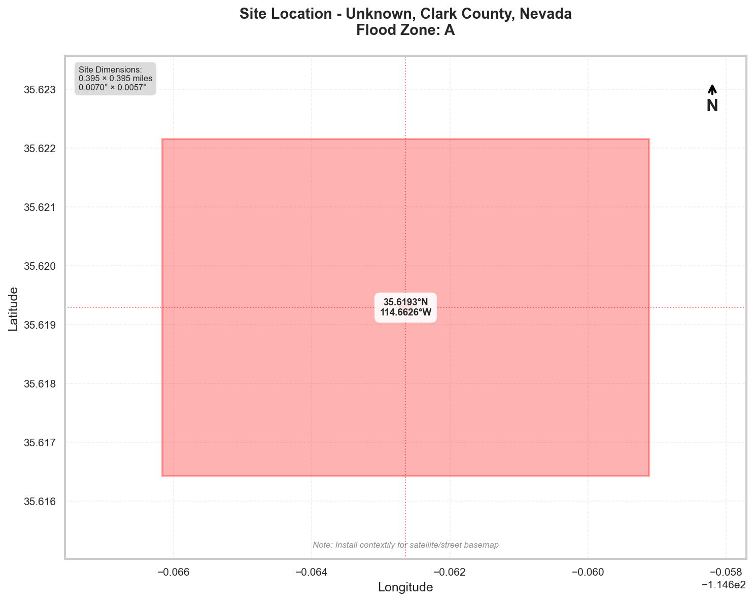
Location: Unknown, Clark County, Nevada
Flood Zone: A - High Risk - Special Flood Hazard Area (1% annual chance)
Site Area: 100.0 acres (0.16 sq mi)
Site Location
Site Information
Geographic Data
- Center Coordinates: 35.619290, -114.662640
- Bounding Box:
- North: 35.622155
- South: 35.616426
- East: -114.659117
- West: -114.666164
- Dimensions: 0.4 mi × 0.4 mi
Flood Zone Analysis
Primary Flood Zone: A
Risk Level: High Risk - Special Flood Hazard Area (1% annual chance)
DFIRM Panel: 32003C
Flood Zone Implications
- ⚠️ HIGH RISK: Property is in Special Flood Hazard Area (SFHA)
- Flood insurance is MANDATORY for federally-backed mortgages
- Floodplain development permit required for any construction
Precipitation Data
✅ Using ACTUAL NOAA Atlas 14 precipitation data
The precipitation values shown below were retrieved directly from NOAA's
Precipitation Frequency Data Server (PFDS) for your specific location.
Verify data at: https://hdsc.nws.noaa.gov/hdsc/pfds/pfds_map_cont.html?lat=35.6193&lon=-114.6626
Location: 35.6192905°, -114.6626405°
Region: Western US
Data Source: NOAA Atlas 14 - Actual Data
Design Storm Summary
- Water Quality Volume (WQv) - 1-year, 24-hour storm
- Depth: 0.817 inches
- Use: BMP sizing for water quality treatment
- Channel Protection Volume (CPv) - 2-year, 24-hour storm
- Depth: 1.06 inches
- Use: Extended detention for channel erosion prevention
- Overbank Flood Protection - 10-year, 24-hour storm
- Depth: 1.78 inches
- Use: Detention sizing for flood mitigation
- Extreme Flood Protection - 100-year, 24-hour storm
- Depth: 3.02 inches
- Use: Emergency spillway and freeboard design
Precipitation Frequency Estimates
| Return Period | 5-min | 10-min | 15-min | 30-min | 60-min | 2-hr | 3-hr | 6-hr | 12-hr | 24-hr | 2-day | 3-day | 7-day | 10-day |
|---|---|---|---|---|---|---|---|---|---|---|---|---|---|---|
| 1-yr | 0.123 in | 0.187 in | 0.232 in | 0.313 in | 0.387 in | 0.477 in | 0.529 in | 0.636 in | 0.752 in | 0.817 in | 0.88 in | 0.919 in | 1.06 in | 1.14 in |
| 2-yr | 0.164 in | 0.25 in | 0.309 in | 0.417 in | 0.516 in | 0.63 in | 0.693 in | 0.833 in | 0.987 in | 1.06 in | 1.15 in | 1.2 in | 1.38 in | 1.48 in |
| 5-yr | 0.241 in | 0.366 in | 0.454 in | 0.611 in | 0.756 in | 0.905 in | 0.983 in | 1.17 in | 1.38 in | 1.46 in | 1.57 in | 1.63 in | 1.84 in | 2.0 in |
| 10-yr | 0.304 in | 0.462 in | 0.572 in | 0.771 in | 0.954 in | 1.14 in | 1.22 in | 1.44 in | 1.68 in | 1.78 in | 1.9 in | 1.96 in | 2.18 in | 2.37 in |
| 25-yr | 0.397 in | 0.604 in | 0.749 in | 1.01 in | 1.25 in | 1.49 in | 1.58 in | 1.84 in | 2.11 in | 2.24 in | 2.37 in | 2.43 in | 2.63 in | 2.85 in |
| 50-yr | 0.477 in | 0.725 in | 0.899 in | 1.21 in | 1.5 in | 1.79 in | 1.88 in | 2.18 in | 2.46 in | 2.61 in | 2.75 in | 2.8 in | 2.97 in | 3.21 in |
| 100-yr | 0.567 in | 0.863 in | 1.07 in | 1.44 in | 1.78 in | 2.14 in | 2.23 in | 2.55 in | 2.84 in | 3.02 in | 3.16 in | 3.2 in | 3.32 in | 3.56 in |
For complete precipitation data including all durations, visit the NOAA PFDS
Rainfall Intensity (for Rational Method)
- 10 yr, 5 min: 3.65 inches/hr
- 25 yr, 5 min: 4.76 inches/hr
- 100 yr, 5 min: 6.8 inches/hr
Precipitation Visualizations
Intensity-Duration-Frequency (IDF) Curves
Precipitation Summary
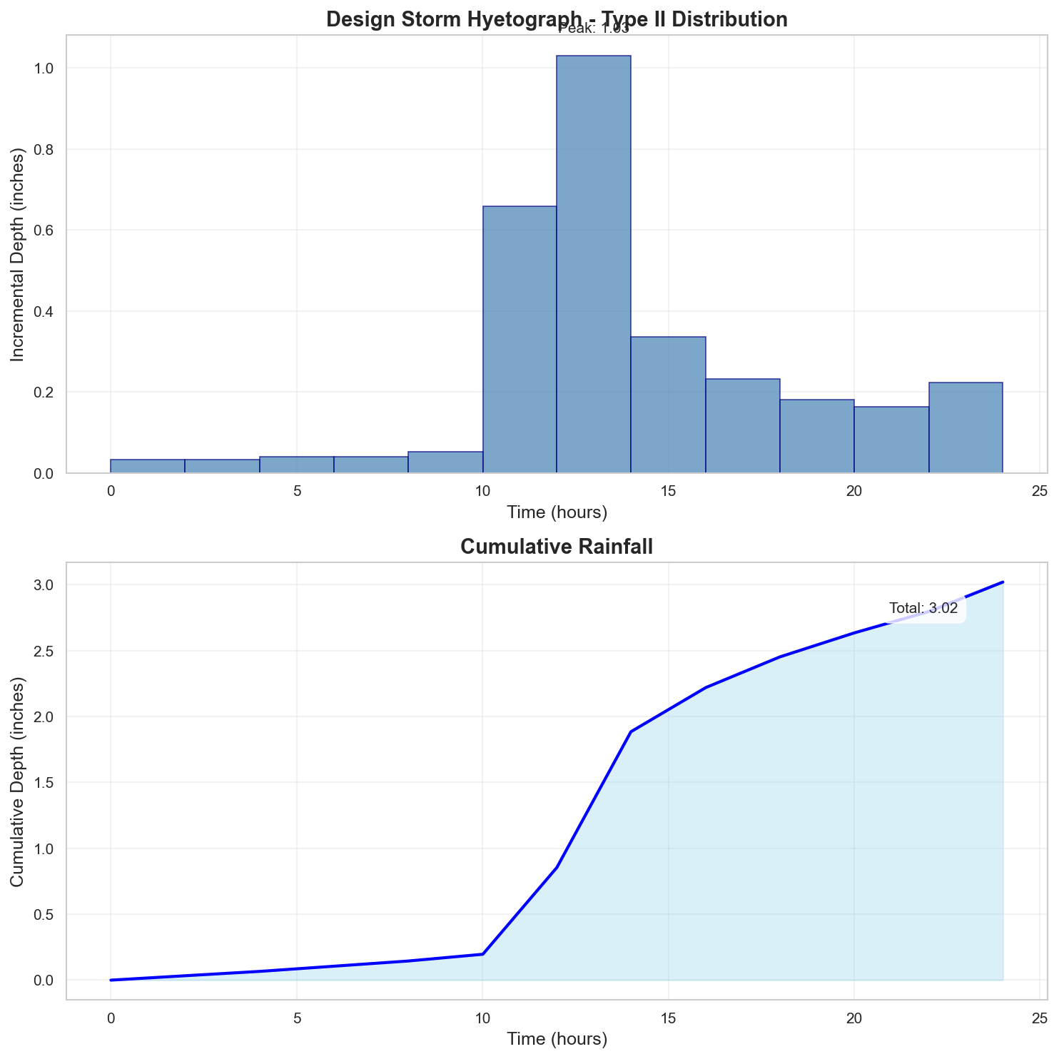
100-Year Design Storm Hyetograph
Regulatory Analysis
Jurisdictional Overview
- Federal: FEMA, USACE (if wetlands present)
- State: Nevada
- County: Clark
- City: Unincorporated area
Permit Requirements
Research conducted: 2025-09-08T13:08:43.838423
Based on the specific parameters for your 100.0-acre site in Flood Zone A in Clark County, Nevada, here are the EXACT requirements:
1. STATE-LEVEL PERMIT REQUIREMENTS
Nevada Division of Environmental Protection (NDEP)
- Construction General Permit: NVR100000 REQUIRED (100 acres > 1 acre threshold)
- Notice of Intent (NOI) must be filed electronically via EPA's NPDES eReporting Tool
- SWPPP Required: Must be prepared by qualified person (no state RLD program)
- State Fees: $1,200 annual fee for sites ≥5 acres
- Timeline: 14-day waiting period after NOI submission
- No separate state stormwater management permit
- No state wetland permit (defers to USACE for Waters of the US)
APPROXIMATE Contact (verify current):
- NDEP Bureau of Water Pollution Control
- Phone: Search "NDEP stormwater permit"
- Website: Search "Nevada NDEP Construction General Permit"
2. LOCAL PERMIT REQUIREMENTS
Clark County Regional Flood Control District (CCRFCD)
REQUIRED PERMITS for 100-acre Zone A site:
- Drainage Study Permit
- Form: DS-1 (Drainage Study Checklist)
- Fee: $3,500 base + $35/acre over 40 acres = $5,600
- Submittal: 3 paper copies + 1 digital (PDF)
- Review Timeline: 30-45 days initial review
- Zone A Floodplain Development Permit
- Form: FP-1 (Floodplain Development Application)
- Fee: $1,500 + $500 Zone A study review = $2,000
- Required: Base Flood Elevation determination study
- Review Timeline: 45-60 days (includes Zone A analysis)
- Grading Permit (if mass grading)
- Through Clark County Building Department
- Fee: Based on cubic yards (approximately $5,000-$10,000 for 100 acres)
SUGGESTED Search Terms for Forms:
- "CCRFCD drainage study checklist"
- "Clark County floodplain development permit"
- "CCRFCD permit applications"
3. PERMIT SEQUENCING AND COORDINATION
CRITICAL SEQUENCE for 100-acre Zone A site:
- FIRST: Zone A Base Flood Elevation determination
- SECOND: CCRFCD Drainage Study approval
- THIRD: CCRFCD Floodplain Development Permit
- FOURTH: NDEP Construction General Permit NOI
- LAST: Building/Grading permits
No combined applications - each agency separate
Total Timeline: 90-120 days minimum
4. TECHNICAL CALCULATIONS
FOR YOUR 100-ACRE ZONE A SITE:
Precipitation Data Requirements:
- NOAA Atlas 14 values NOT directly accepted
- REQUIRED: Clark County 2019 Manual precipitation values:
- 100-year, 6-hour: 2.50 inches (NOT 24-hour)
- 10-year, 6-hour: 1.50 inches
- Your NOAA values must be converted using County factors
Required Calculations:
- Software: HEC-RAS 5.0.7 or newer for Zone A analysis
- Runoff: Clark County Rational Method for <300 acres OR HEC-HMS
- CN Values: Per Table 3-2 of County Manual (desert soils)
- Tc: Kirpich equation with County adjustment factors
Zone A Specific Requirements:
- BFE Determination: 2D HEC-RAS model required
- Cross sections: Minimum 4 per mile
- Floodway analysis: Required for 100 acres
5. DESIGN STANDARDS
CRITICAL FREEBOARD REQUIREMENTS:
- State Requirement: None specified (defers to local)
- Clark County Requirement: 2.0 FEET above BFE
- For Zone A: 2.0 feet above YOUR DETERMINED BFE
- YES - Local exceeds FEMA 1-foot minimum
- Source: Title 32, Section 32.04.030(B)
100-Acre Zone A Specific Standards:
- Retention Required: First 0.75 inches over entire 100 acres
- Detention: 100-year post = 100-year pre-development
- Emergency Spillway: Pass 500-year event
- 1/4-1/4 Rule: Maximum 25 acres can drain to any property line quarter
6. SUBMITTAL DETAILS
State (NDEP):
- Electronic only via EPA eReporting
- PE certification required for SWPPP
Local (CCRFCD) for 100-acre Zone A:
- Drainage Report: 3 copies, 24"×36" plans
- Zone A Study: Separate technical report required
- Digital: PDF on CD/USB, CAD files optional
- Certifications: Nevada PE required for all
7. STATE AGENCY CONTACTS
APPROXIMATE Information (verify current):
- NDEP Main: Search "NDEP Bureau Water Pollution Control"
- Las Vegas NDEP Office: Search "NDEP Southern Nevada office"
- Stormwater Program: Search "Nevada construction stormwater permit contact"
8. LOCAL CONTACTS AND RESOURCES
APPROXIMATE Information (verify current):
- CCRFCD Main: Search "Clark County Regional Flood Control District"
- Floodplain Administrator: Search "Clark County floodplain manager"
- Technical Questions: Search "CCRFCD engineering staff directory"
- Applications: Search "CCRFCD permit applications forms"
CRITICAL ZONE A REQUIREMENTS FOR YOUR SITE:
- Base Flood Elevation must be determined before any permits
- 2-foot freeboard applies once BFE established
- Floodway determination required due to 100-acre size
- No LOMR-F available in Zone A (must do full analysis)
- 96-hour drawdown for retention basins in desert soils
VERIFICATION NEEDED:
- Current fee schedule (fees change annually)
- Specific contact information
- Current form versions
- Software version requirements
Additional Jurisdictional Information
Based on my research of Nevada and Clark County hydrological permitting requirements, here are the specific regulatory frameworks:
1. STATE-LEVEL REGULATORY AGENCIES
Primary Agency: Nevada Division of Environmental Protection (NDEP)
- Bureau of Water Pollution Control handles stormwater
- Bureau of Water Quality Planning manages TMDLs
- No separate stormwater management division like other states
Key State Programs:
- Nevada's NPDES program (delegated from EPA)
- No state-specific stormwater program beyond NPDES
- Limited state wetland program (relies primarily on federal)
2. STATE REGULATORY REQUIREMENTS
Construction Permits:
- NDEP issues NPDES Construction General Permit (NVR100000)
- 1-acre disturbed area threshold (federal minimum)
- No state-specific threshold below federal requirements
Unique Nevada Requirements:
- NO state-mandated post-construction standards (unlike many states)
- NO state BMP design manual (relies on local jurisdictions)
- NO Responsible Land Disturber certification program
- Professional Engineer (PE) required for certain submissions
3. COUNTY/LOCAL REGULATORY STRUCTURE
Clark County Specific Departments:
- Clark County Regional Flood Control District (CCRFCD) - Primary authority
- Clark County Department of Environment and Sustainability
- Clark County Public Works - Development Review
Key Ordinances:
- Title 32 - Uniform Regulations for the Control of Drainage
- Ordinance 1622 - Las Vegas Valley Flood Control Master Plan
- Title 14 - Water and Sewers
4. UNIQUE LOCAL REQUIREMENTS
Clark County Specifics:
- 2-foot freeboard requirement (exceeds FEMA's 1-foot)
- 0.25-acre threshold for drainage studies (much lower than state)
- Mandatory use of Clark County Hydrologic Criteria and Drainage Design Manual (2019)
- Required software: HEC-HMS, HEC-RAS, or approved alternatives
- Unique "1/4-1/4 rule": No more than 1/4 of site runoff to any 1/4 of perimeter
5. STATE-LOCAL INTERACTION
Permit Sequencing:
- CCRFCD permits required BEFORE state NPDES
- No joint application process
- Local requirements significantly exceed state minimums
- CCRFCD acts as qualifying local program for some requirements
6. TECHNICAL STANDARDS
State Requirements:
- 10-year, 24-hour storm for temporary BMPs
- No specific state detention standards
Clark County Requirements:
- 100-year, 6-hour storm for major drainage
- 10-year, 6-hour storm for local drainage
- Retention required: First 0.75 inches of rainfall
- Specific curve numbers per soil type in manual
- Emergency overflow for 500-year event
7. KEY DOCUMENTS TO REFERENCE
State Documents:
- NDEP Construction General Permit NVR100000
- NAC 445A (Water Pollution Control regulations)
- Limited state guidance documents
Clark County Documents:
- Hydrologic Criteria and Drainage Design Manual (2019)
- Las Vegas Valley Flood Control Master Plan
- CCRFCD Standard Drawings and Specifications
- Drainage Study Checklist (Form DS-1)
- Fee Schedule (Resolution 09-03)
SURPRISING ELEMENTS FOR OUT-OF-STATE ENGINEERS
- Minimal State Oversight: Nevada has surprisingly limited state-level stormwater requirements compared to states like Virginia, Maryland, or California
- Desert Hydrology Focus:
- 6-hour storm durations (not 24-hour)
- Emphasis on channel protection from high-velocity flows
- Retention basins designed to infiltrate within 96 hours
- CCRFCD Authority: The regional flood control district has unusual autonomy and stricter requirements than state
- No State Post-Construction Standards: Unlike most states, Nevada has no state-mandated post-construction stormwater quality requirements
- Unique Local Requirements:
- 1/4-1/4 rule for drainage distribution
- 0.25-acre threshold vs. 1-acre state threshold
- Mandatory retention of first 0.75 inches
- Fee Structure: CCRFCD fees based on both acre-feet of runoff AND review complexity
This regulatory structure reflects Nevada's arid climate and Clark County's rapid urbanization, with local authorities taking the lead on detailed requirements while the state maintains minimal oversight.
Recommended Next Steps
- Verify Flood Zone: Confirm flood zone designation with local floodplain administrator
- Survey Requirements: Obtain professional survey with elevation data
- Preliminary Consultation: Meet with local planning/permitting department
- Engineering Analysis: Engage qualified engineer for required studies
- Permit Applications: Prepare and submit required permit applications
Data Sources
- Location Data: OpenStreetMap Nominatim
- Flood Zone Data: FEMA NFHL (public MapServer)
- Precipitation Data: NOAA Atlas 14 Precipitation Frequency Data Server
- Analysis Date: 2025-09-08 13:10:15
This report is for preliminary analysis only. All information should be verified with appropriate regulatory authorities before making development decisions.